


[lbg_zoominoutslider settings_id=’20’]
Solo American Treks
Across North America
From Washington DC to Glacier Bay, Alaska
on Foot, by Kayak and Small Boat
between 2001 and 2004
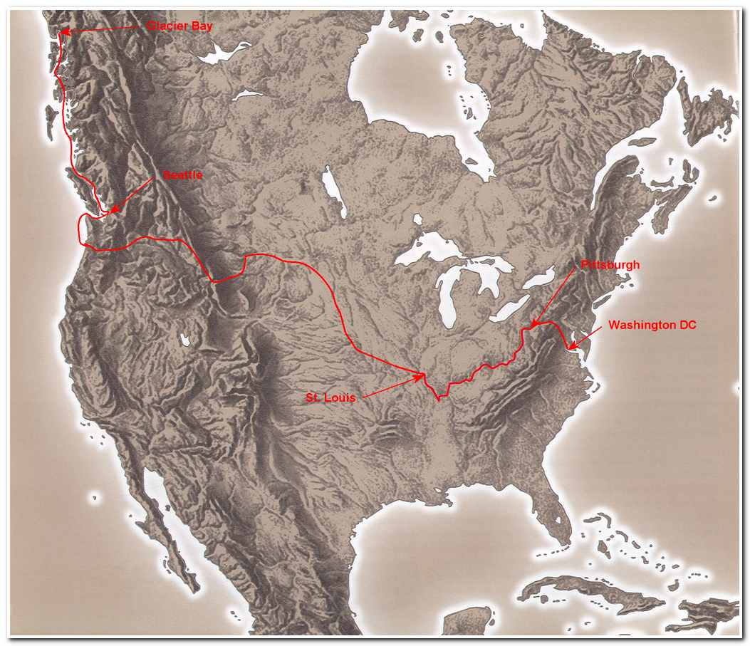
Route from Washington DC to Glacier Bay Alaska
Origins
I have always had a fascination with maps and geography. As a young boy I spent hours pouring over maps and reading about the great adventures of explorers, often imagining myself hiking along beside them on their ground breaking expeditions to the then unknown places across North America. Lewis and Clark and John Wesley Powell exploring the emerging United States in the 1800s. Franklin, Parry, Rae and others forging a path across the Arctic. Livingston and Stanley in Africa. Shackelton, Scott and Mawson in Antarctica. Edward Whymper in the Alps and Hillary and Shipton in the Himalayas. As I grow older this fascination with the unknown continued to grow as well. I had spent a large portion of my adult years in the mountains and had climbed over 400 peaks in the United States in the Cascades the Sierras the Rockies the Tetons and the Appalachians. Over the years I climbed or walked to the top of 49 of the 50 state high points. I had also climbed in Mexico, Guatemala, Ecuador and in the Alps. During the 1970s, 80s and 90s I led or participated in over a dozen different expeditions to the Arctic, climbing and man hauling a sled, sometimes following in the footsteps of those early explorers and sometimes climbing and exploring in hitherto unexplored mountain ranges.
Then in about 2001 I became interested in doing something completely different; undertaking long distance transcontinental trips. Since I was now retired from a career in banking I had the time to spend indulging my urge and set about planning a multiphase 6400 mile trip across North America from Washington DC to Seattle and north to Glacier Bay, Alaska.
The origins of the trip date back to the third grade when I studied a map of North America hanging on the wall of Miss Redmond’s third grade classroom. As I looked at the map I was fascinated by the complex river system of North America and I tried to find an all water route from the Atlantic to the Pacific. This allusive route was not to be, however, I did find a route that nearly made it, but for about 80 miles in the continental divide area of western Montana. My route started in Washington DC and followed the Potomac River to Cumberland Maryland then overland to the Casselman and Younghiogheny Rivers to the Monongahela River and the Ohio River at Pittsburgh and then the Ohio to the Mississippi River. From the Mississippi my route continued upriver to the Missouri River, then to the Yellowstone river, up the Yellowstone to the continental divide and then overland again to the headwaters of the Snake River in Wyoming, then down the Snake to the Columbia River and on to the Pacific Ocean. Once I had ‘discovered’ my transcontinental route I filled in the details by reading about Lewis and Clark and other early American explorers and pledged to myself that one day I would undertake to travel this route.
In the spring of 2001 while entertaining the idea of a traverse of North America I once again thought of this route and decided to get serious about undertaking it. I pulled out maps and began researching the route in more detail. The route I came up with is largely the same as the one I had ‘discovered’ 45 years earlier plus I decided to add a 1298.6 mile section from Seattle to Glacier Bay Alaska. The “new” route began in Washington DC and followed the C and O Canal trail 187 miles to Cumberland Maryland then 133 miles along the Alleghany Highlands Trail to McKeesport Pennsylvania. From McKeesport 994 miles by boat, first down the Monongahela River to the Ohio River at Pittsburgh and then down the Ohio to Cairo Illinois, 195 miles up the Mississippi/Missouri River confluence near St. Louis. I would then travel by boat and kayak 2321.5 miles along the Missouri to its headwaters near Three Forks Montana (bypassing the Yellowstone). From Three Forks I would kayak the Jefferson River for 80 miles to Twin Bridges Montana and then 78 miles on the Beaverhead River to the Dillon Reservoir near Dillon Montana and then make a long hot hike 117 miles across the Big Hole and over the continental divide to the headwaters of the Bitterroot River at Conner Montana. I would then take to the kayak once again for 71 miles to Lolo Montana where I would hike 135 miles over Lolo Pass to Kooskia Idaho and the headwaters of the Clearwater River. Once at Kooskia I would kayak 75miles to Lewistown Idaho to the Snake River and then 128 miles down the Snake to the Columbia River at Pasco, Washington. From Pasco I would take a 22 foot open boat boat 325 miles to the Pacific Ocean at Ilwaco Washington. From Ilwaco I would take the boat across the Columbia River bar and up the coast of Washington State 294 miles to my home on Whidbey Island Washington. The last leg of the trip would be a sometimes harrowing 1298.6 miles in this same small boat to Glacier Bay, Alaska, ending the trip at the snout of the Johns Hopkins Glacier.
This then would be my introduction to long distance trekking, 6432.1 miles of travel through the heart of North America and along Pacific coast to Alaska. I would have encounters the badgers, rattlesnakes and whales. I would meet many wonderful people in ‘fly over country’. I would travel the calm waters of the Missouri, the rapids of the Bitterroot and Clearwater rivers and the terrifying stormy waters of Alaska. The trip would prove to be long and hard, but worth every minute of it!
April 2008
Steve Trafton
Note: I have described the trip as proceeding from east to west and this narrative will describe the trip from Washington DC to Alaska,when in reality some of the sections of the trip were done from west to east depending on the direction of the river flows. In the narrative which follows my description of each east to west segment is as the segment was actually traversed.