


Kayaking
Great Falls to Fort Peck, Montana
 May 16th 2003
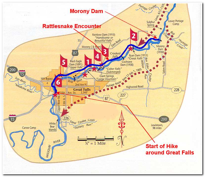
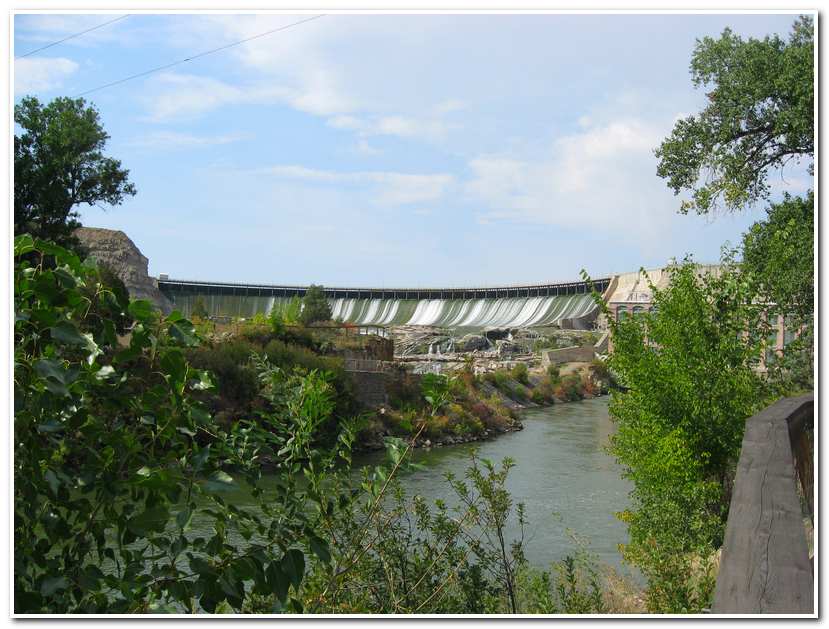
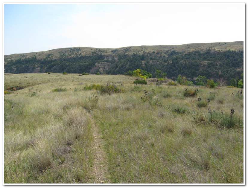
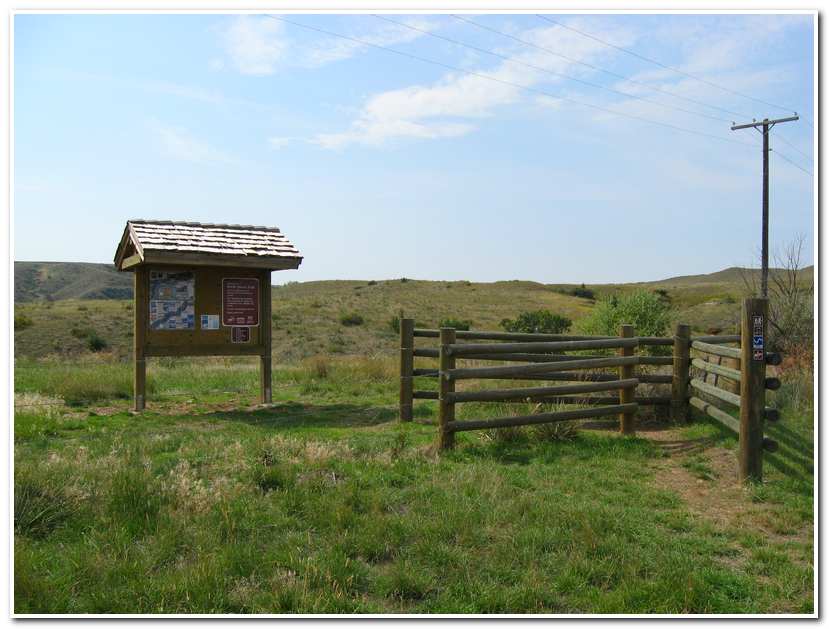
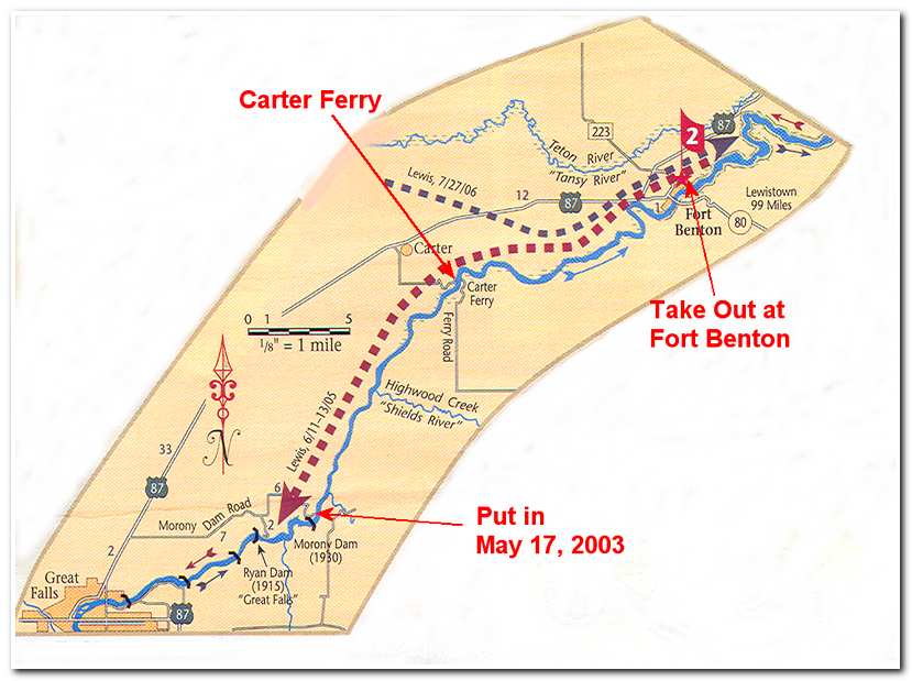
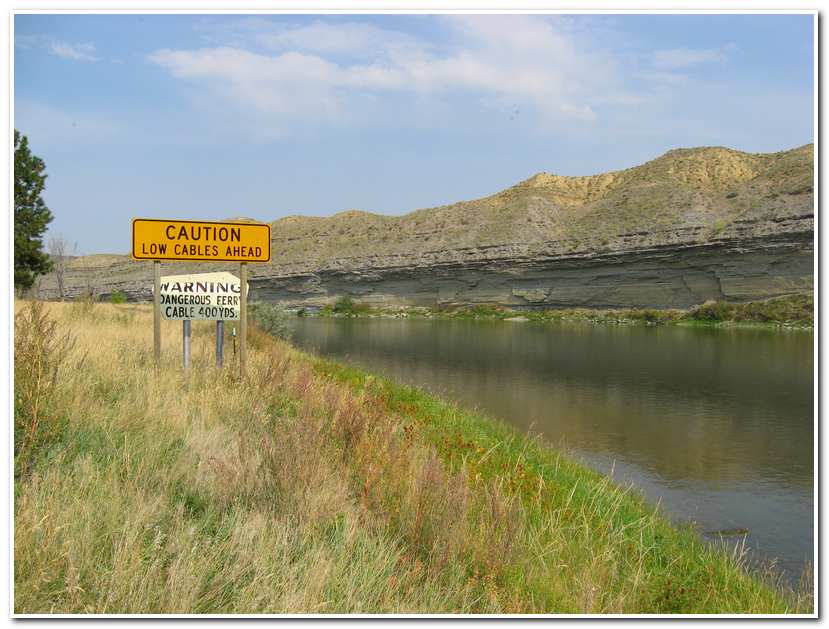
The following May (2003) James and I returned to continue our route kayaking the Missouri from Great Falls to Fort Peck. But first came Fort Benton some 46 miles further down the river. This section consisted of two segments. Like most of the kayak trips it involved some hiking too. The first would be a 20 mile hike from the Great Falls take out, around the city named for it, past five dams to a put in below Morony Dam. Then a 31 mile paddle from here to the town of Fort Benton. After driving to Great Falls on May 15th we started our hike at 8:45 on the morning the 16th under bright sunny skies. Our route followed the riverfront road on the right shoreline for 0.5 miles and then crossed a bridge over the river and followed the left shoreline on a developed trail for several miles before turning inland and going around the Black Eagle community and Black Eagle Dam before returning to the river and continuing on past Rainbow Dam.
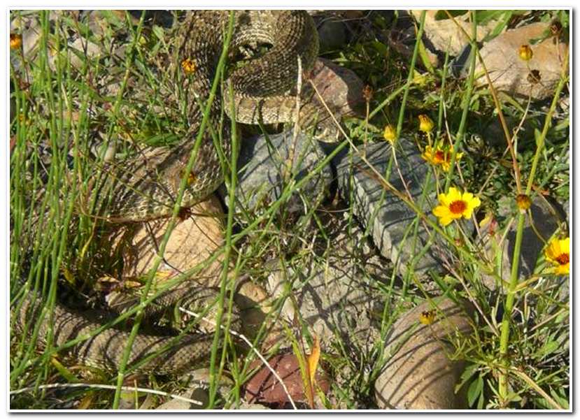
From here the trail rose and followed the rugged bluffs along the river for about 3 miles to Cochrane Dam. While we were hiking the trail between the two dams we kept a sharp eye out for rattlesnakes which we were told are common along the trail. At one point I was about thirty yards ahead of James and lost in thought reciting ‘The Cremation of Sam MacGee’ to myself when suddenly about three feet in front of me I saw a well camouflaged snake slither quickly off the trail. As I remember it, I jumped a good eight feet to the side, just from the shear sudden movement. The snake continued on into the brush and coiled menacingly, but was by now well away from trail and presented no threat. After the initial shock of the encounter I thought about how interesting it was that even though I was casually looking for snakes at the time, he blended in with environment so well that I didn’t see him until I nearly stepped on him. At any rate, take note, rattlesnakes are hard to see!
After the snake encounter we soon came to Ryan Dam and then continued on along the side of the river alternating between the trail part way up the bluffs and the river bottom until we finally reached Morony Dam. It was then just a short hike past the dam to the put in site we would start from the next. I would describe this hike as pleasant but long and I would definitely not want to undertake it on a hot summer day.
-

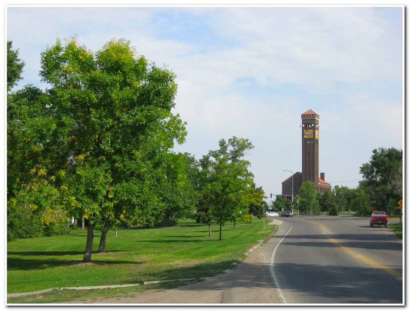
- Old Railroad Station Clock Tower in Great Falls
-
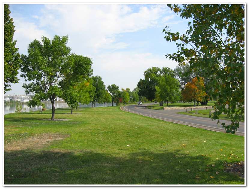
- Trail along Riverfront Park in Great Falls
-
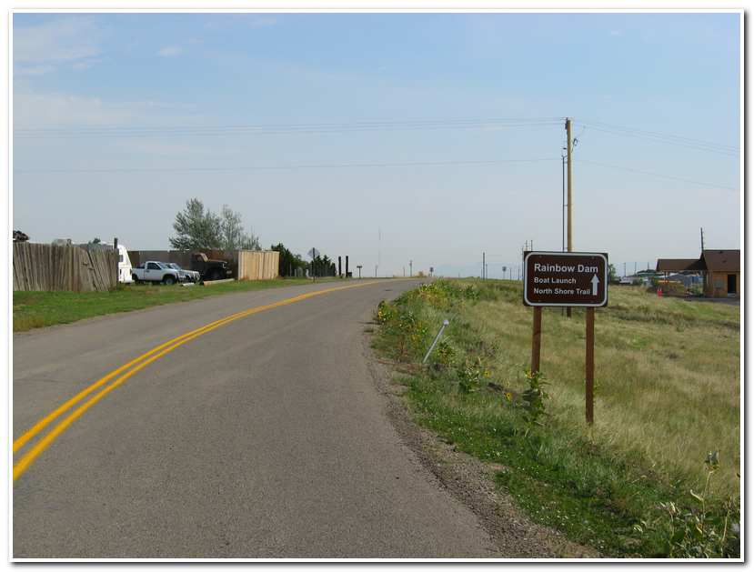
- Along the walk to Rainbow Dam
-
- Rainbow Falls
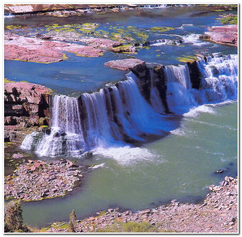
-
- Crooked Falls are is the foreground, with the 48 foot Rainbow Falls and Rainbow Dam up river.
-
- Wheatfield outside Great Falls

-
- Rattlesnake along the trail between Rainbow and Cockrane Dams.
-
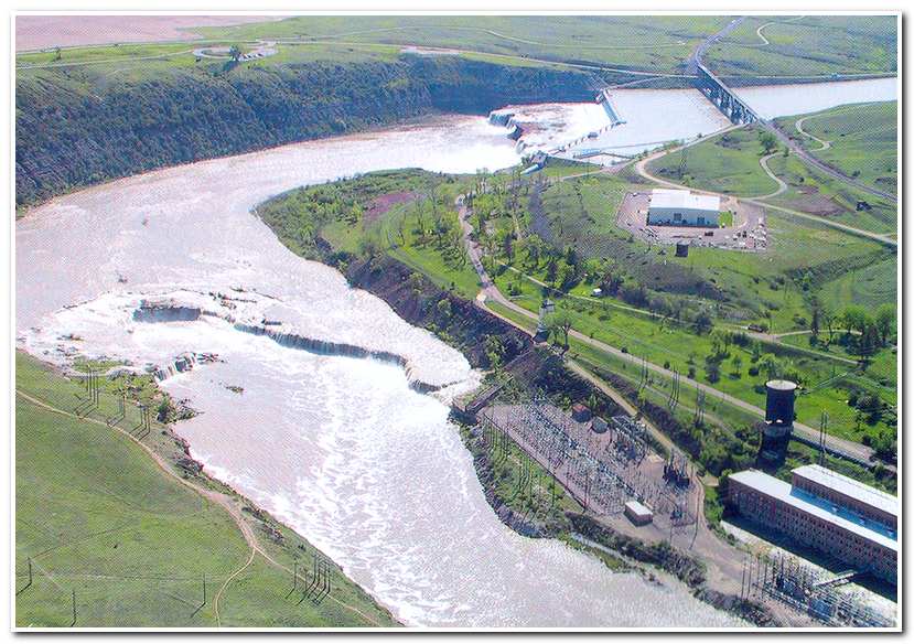
- Ryan Dam; Great Falls is in the background. The trail followed the river edge and bluffs on the right.
-
- Ryan Dam
-
- On the trail downstream from Ryan Dam

-
- On the trail between Ryan and Morony Dam
-
- Trailhead above Morony Dam
-
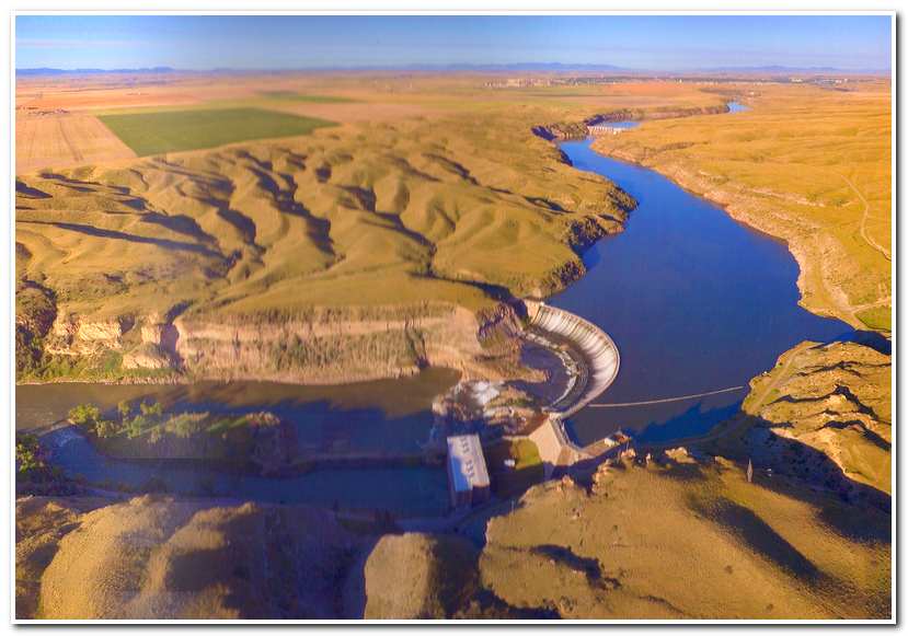
- Morony Dam
 Route of May 17th 2003
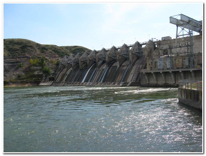
The next day (May 17th) James and I were at the Morony Dam put in by 8:00 and ready to start for Fort Benton. In retrospect I would recommend that experienced paddlers should put it below Morony Dam. Although the route is less difficult at water times, the first set of rapids (class 2 and Class 3) below the dam is nearly a mile in length and there are dangerous shelves along the canyon sides and many sharp edged boulders that have to be avoided. The water is fast and the consequences of hitting any of these boulders would be catastrophic to the kayak and perhaps to the paddler. Two paddlers drown here a year after James and I run these rapids.
From Morony Dam (8:30) it is 3.5 fast paced miles to Widow Coulee on the right. About 2.5 miles further downstream we passed by an old cabin in an open area near the mouth of Highwood Creek (10:10; 6 miles) on the right and once around the next bend the river began to straighten out considerably and we ran a short section of modest rapids. After the rapids we paddled for another 1.5 miles and worked our way through two short sections of fast water. After this the river straightened again for about 2 miles and there were areas of level land on the left before we came to Black Coulee (12.5 miles from Morony Dam). Once rounding the bend at Black Coulee we passed through several sets of small rapids and shallow water before arriving at Carter Ferry (12:10; 15.5 miles).
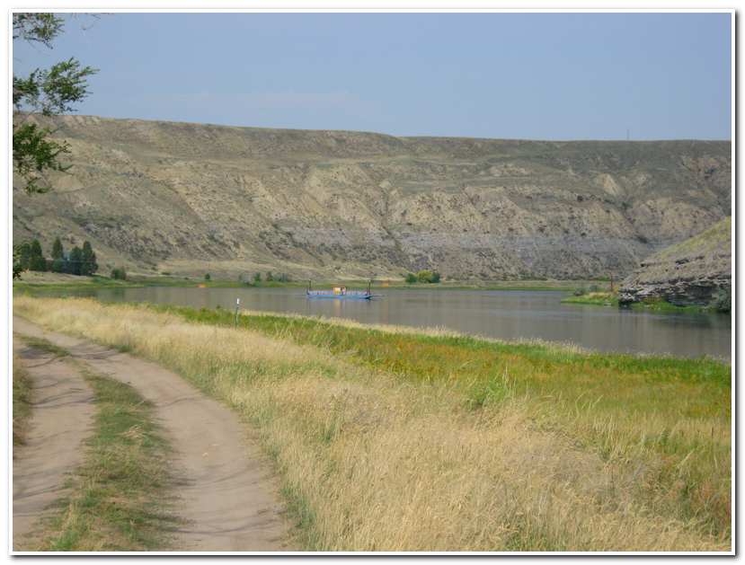
Carter Ferry is the only river crossing between Great Falls and Fort Benton and presents a unique challenge of its own for any kayaker passing by. The ferry is attached to a low hanging cable that is strung across the river. The cable nearly touches the water in the center and then rises slowing on either side to where it is attached to its supporting stanchions. In order to pass safely we had to paddle hard to get for enough to the right side of the river to pass beneath the cable. I barely made it through, James wasn’t so lucky and got ‘clothes lined’ by the cable and capsized. Fortunately he was able to stay with his kayak and I paddled back upstream and towed him shore. He was unhurt, but soaked so we took a half hour break while he changed into dry cloths and warmed up before we continued on our way. The remainder of our trip was uneventful as we paddled through calm waters with a good currant for 12 miles before reaching the Cottonwood Bottom, just to the west of Fort Benton. Here we entered three mile long sweeping oxbow bend that emerged at the outskirts of the town (3:00). The last mile of our trip was along the waterfront of Fort Benton, under the bridge and to the take out at the boat ramp on the eastern side of town (32.5 miles; 3:40).
-
- Put in below Morony Dam
-
- The dangerous rapids at Portage Creek below Morony Dam
-
- Old Cabin below Widow Coulee
-
- Approaching Carter Ferry
-
- Carter Ferry
-
- About two miles from Fort Benton
-
- Nearing Fort Benton
-
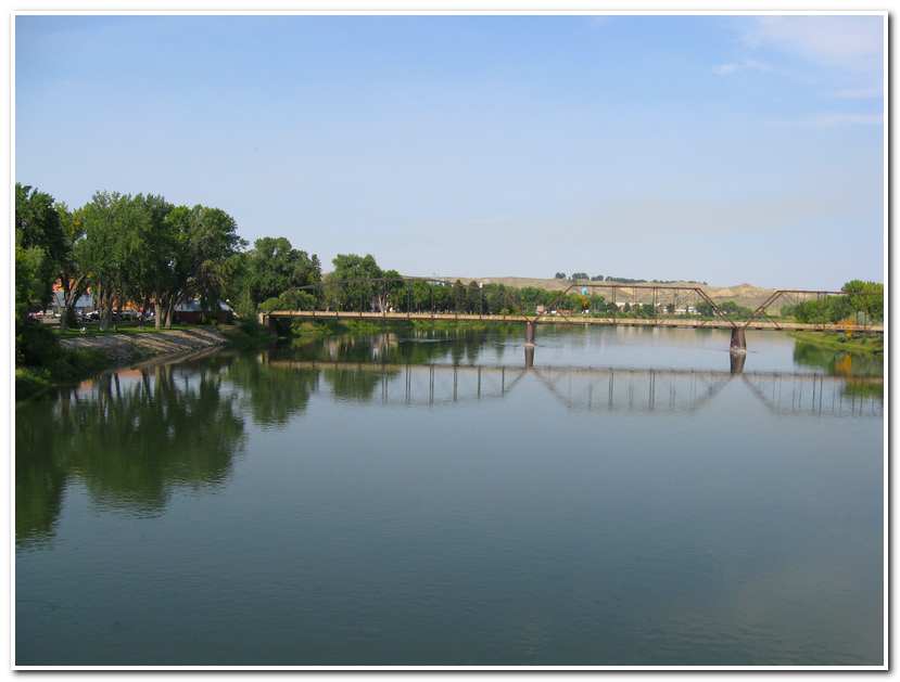
- Fort Benton riverfront
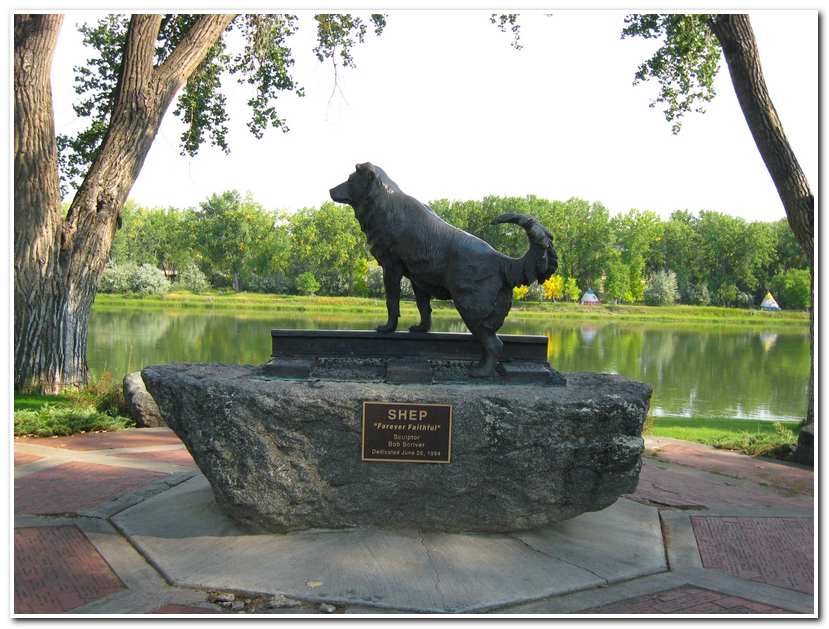
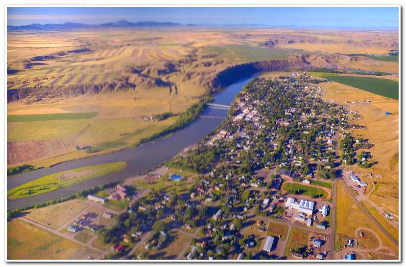
The town of Fort Benton is located at the historical end of steamboat navigation on the Missouri River during the late 1800s. The firs steamboat reached the town in 1860, and gold was discovered in the northern Rockies in 1862, it became the main jumping off point for prospectors on their way to the gold fields. Is also the famous as the home of ‘Shep,’ the sheepdog that became famous as a symbol of the loyalty between a dog and his master.
The Story of Shep
Shep was born in the early 1930s and his master was probably a foreign born son of an immigrant from one of the sheep-raising areas of Europe. There was a demand for both good shepherds and good dogs to protect the Montana flocks from coyotes and other predators. A familiar sight in north central Montana was a lonely sheep wagon standing on some distant ill. Its horses were usually grazing nearby, and a herder and his dog could be seen tending two or three thousand woolies.
In those days Montana was sheep country as well as wheat country. The 1930s saw a surge in wool and sheep production in the state; they were among Montana’s main industries until after World War II.
The early years of Shep’s life were the years of the depression. Flocks grazed on the parched dry prairie; wool and sheep sold for little or nothing in the marketplace, The herder and his dog worked for little more than grub, a wagon and a few dollars of spending money. It was a free life, sometimes lonely, but for a man and his dog the bonds grew tight as they lived in harmony with nature under the Big Sky.
From his early days as a puppy, Shep’s fondness for his master must have firmly established. As he grew older, the many days and nights he spent with the herder and their flocks of sheep forged an inseparable bond between man and dog. During the summer of 1936 herder fell seriously ill while tending his flock and was brought to the St. Clare Hospital in Fort Benton, where the Sisters of Charity for Providence and Dr. Anderson cared for him. The dog followed his master to town and set up a vigil at the hospital’s doorstep. Sister Genevieve, a kind hearted nun who ran the hospital kitchen, fed him during those few days before the herder died.
The herder’s family in the East requested that his body be sent back home. On that late summer day the undertaker put the body on the east-bound train for shipment to his waiting relatives. As the gurney was rolled out onto the platform, a big gaunt shepard dog with watchful eyes appeared out of nowhere. The casket was loaded into the baggage car. Attendants recalled the whining dog as the door slammed shut and the engine slowly started to pull away from the station. The dog, head down, turned and trotted down the tracks. On the day the dog, later named Shep, began a five and a half years’ vigil that was only broken by his death.
Day after day, meeting four trains daily, Shep became a fixture on the platform, He eyed each passenger hopefully, and was often chased off as a mongrel but was never completely discouraged. Shep always returned to meet the next train. For the first few months the station workers paid little attention to Shep as passengers arrived and departed. As those first few days passed, Shep was seen going to and from the river, which was over a mile away, for water. But he was always back at the station to meet the next rain. The vigilant Shep grew thinner and thinner on the little food he could scavenge for food.
As winter hit the northern plains in 1936, Pat McSweeney, the section boss, took pity on the dog. He first tried to coax him into living at the section house that was several hundred yards down the track from the depot. Shep would have nothing of it. In his own aloof way, as he ignored all who were around him, Shep even refused a new home and good food in favor of his quarters under the platform. Finally Pat took food and water to him, and Shep began to accept help from the people on the railroad.
Shep soon became a celebrity among the people of Fort Benton. Town kids rode their bikes up the hill to the station to see and passengers on the Great Northern trains hung out of the windows at the station to catch a glimpse of him. Shep never failed to appear during his long vigil.
As time passed, Shep grew to accept the attention his notoriety brought him. He could be petted but followed no one, accepted food but not a home. His place was at the station platform, waiting for his master to return. Nothing else seemed to matter. When he first took up residence under the station’s platform, he was a one-man dog. That never changed.
He accepted some things but befriended no one. During his last years as his points stiffened and the cold affected him more, he favored a bed by the fire in the depot instead of his place under the platform. The dining cars fed him on the platform, some days there was even steak; but first the passengers were always checked before his meal. Every now and then a person might get a little tail wag when petting him, but to the end Shep’s one mission in life was to wait for his masters’ return.
Shep had been an older dog when he came to the station house in Fort Benton. Throughout his vigil the long nights under the platform and the cold winters had taken their toll. Stiff-legged and hard of hearing, On January 12, 1942 Shep failed to hear the train approaching the station. He turned to look when the engine was almost upon him, moved to get out of the way, and slipped on the icy rails. Shep’s long vigil had ended.
No two friends are closer than a sheep herder and his dog. The long days and nights working together to tend the flocks makes man and dog inseparable. Like some people, Shep was exceptional. His loyalty went far beyond others. On that cold January morning Shep found his master again on some pastoral plain where their companionship was renewed forever.
-
- Fort Benton Railroad Station

-
- Shep’s burial site on the hill overlooking the Fort Benton train station

-
- Memorial to Shep on the riverfront in Fort Benton
-
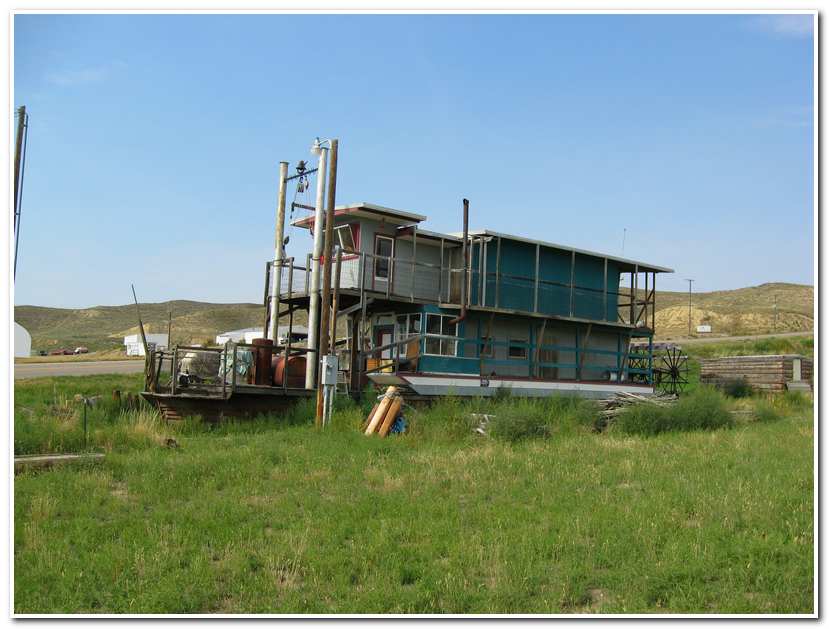
- Remains of an old riverboat ashore in Fort Benton
-
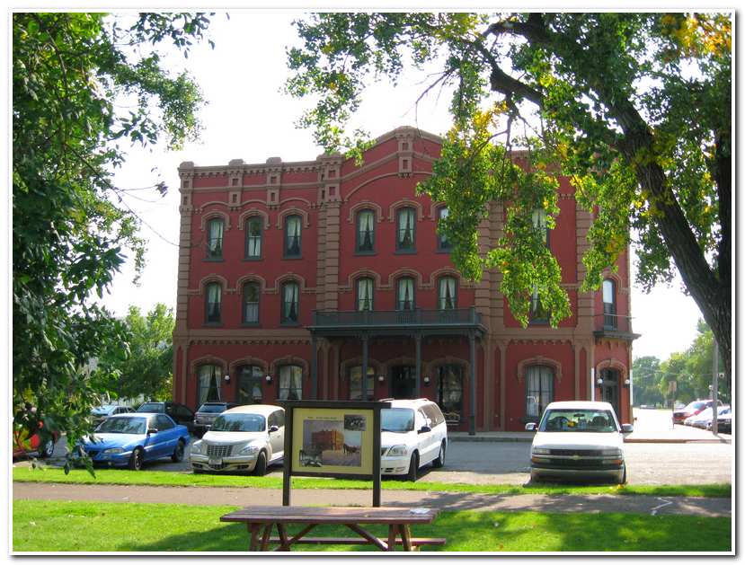
- The Grand Union Hotel in Fort Benton
Section #2 Fort Benton, Montana to Fort Peck Dam, Montana: 303 miles
I returned to Fort Benton on the 29th of May 2003 and checked into the historic Grand Union Hotel ready to undertake the next section of my trip down the Missouri. After a great dinner at the dinning room of this restored landmark hotel and went upstairs to my room with a view of the river and read, savoring a last restful evening before my 153 miles journey down the river to Kipp Recreation Area.
 Section One of the Route Taken May 30th 2003
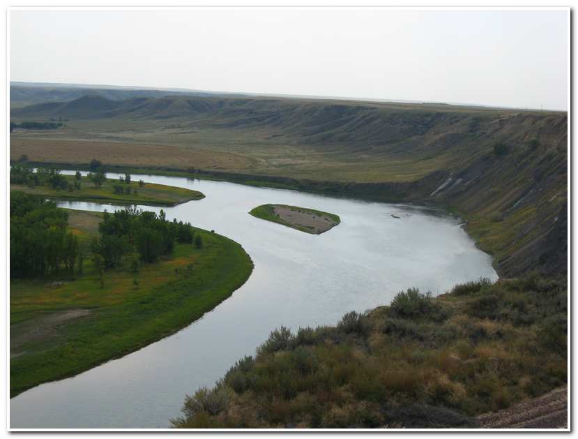
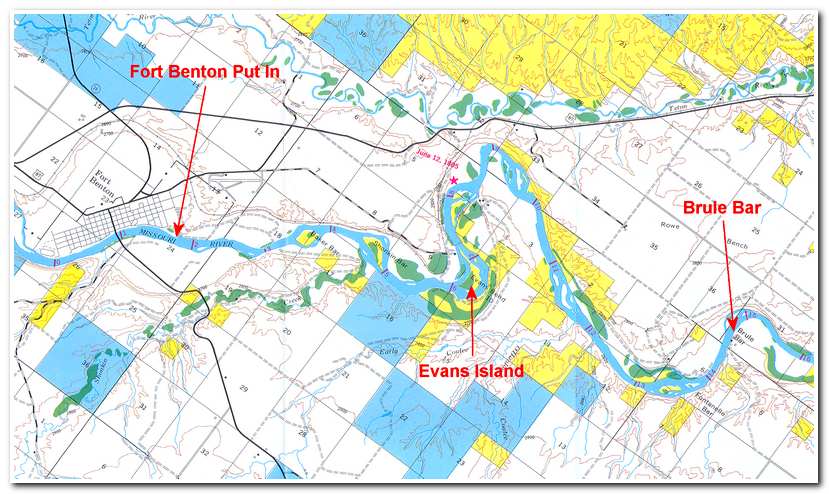
After a big breakfast at the Grand Union I walked down to the boat launch ramp and loaded my gear in the kayak and set out (9:45) in a 4 to 5 mile per hour current downstream. After a mile and a half I passed by Baker Bar and around several bends and shallow areas past Shonkin Bar until I came to the sharp 120 degree bend around Evan’s Island (6 miles).
From here the river angled northwest before turning past the steep cliffs of Crocon du Nez (8 miles; 10:50) and heading southeast through more shallow areas with steep hills on both sides of the river. At Brule Bar (14 miles; left side; 11:40) the river took another sharp bend past shear cliffs on the left before entering a series of bars and shallows. Brule Bottom, on the right of the river, is the former site of Fort McKenzie. Built in 1832 to trade with the Piegans, Bloods and Blackfeet, the life of Fort McKenzie was cut short in January of 1844 when a party of young Blackfeet warriors returning from the Crow country asked admittance to the fort and were refused. The warriors retaliated by stealing or killing some of the fort’s livestock. A well armed party pursued them, but in the fray the fort manager’s black slave was killed and scalped. Vowing revenge, they loaded the fort’s cannon with 150 or so lead bullets, aimed it at the approach to the main gate and waited for the next Indian trading party.
In February, a small band of either Piegans or Bloods arrived to trade. Before the cannon could be fired one man opened up with his rifle killing one chief, the Indians scattered. Several more Indians were killed in the ensuing fray. After this further peaceful trade at the fort was impossible and in about April 1844 the fort was abandoned and trade was reestablished downriver at the mouth of the Judith River. Fort McKenzie was then burned by either whites or Indians, and to this day the site is known as Brule (burned) Bottom.
 Section Two of the Route Taken May 30th 2003
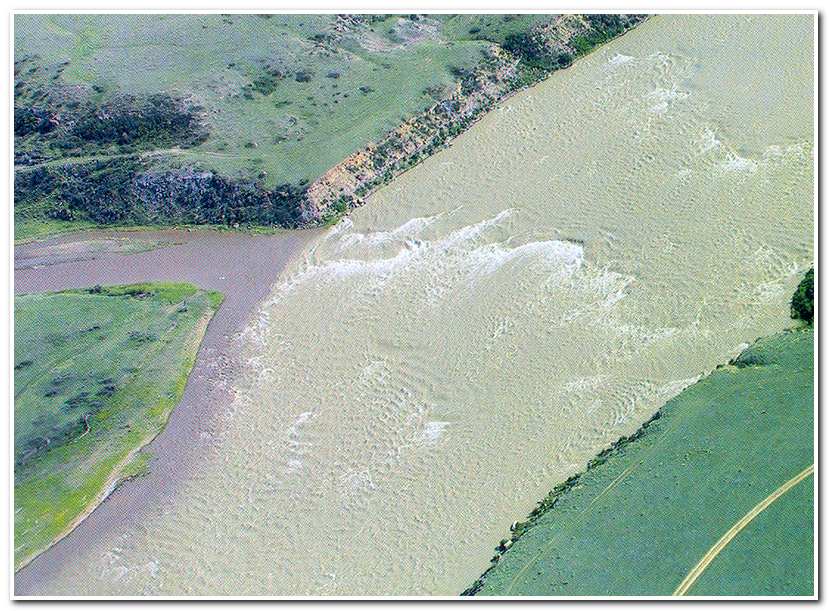
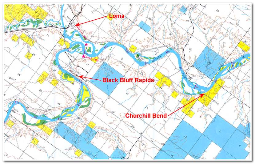
This section of the river was spiced up with a passage through Black Bluff Rapids (19 miles). These rapids weren’t all that difficult but they did keep me alert and gave a refresher course in reading the river for the safest route. Shortly afterward I came to the Loma Bridge, the site of the old Loma Ferry (20 miles: 12:30). The ferry has recently been replaced by a modern bridge across the river, thus easing the passage of vehicles over the river as well as boats along the river. Immediately after Loma Ferry I passed the mouth of the Marias River. Lewis and Clark named this confluence “Decision Point,” where the expedition paused for ten days to figure out which river was the continuation of the Missouri.
The Marias River enters from the left and the river meandered a lot here so the exact confluence was hard to detect (24 miles: 1:30). The calm water and moderate current then carried me on past Churchill Bend and Three Islands (29 miles) to the shallows at Crow Coulee Bar (32 Miles).
 Section Three of the Route Taken May 30th 2003
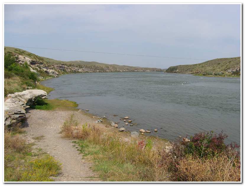
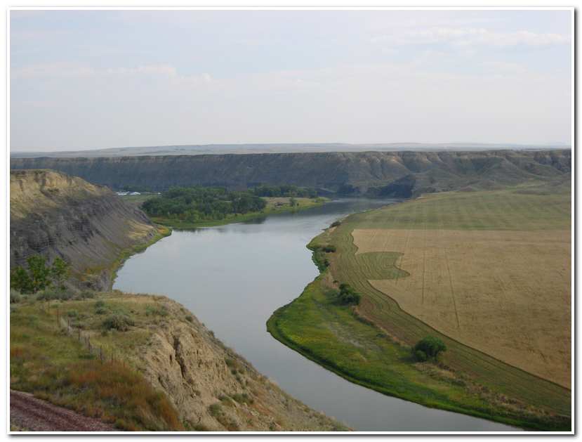
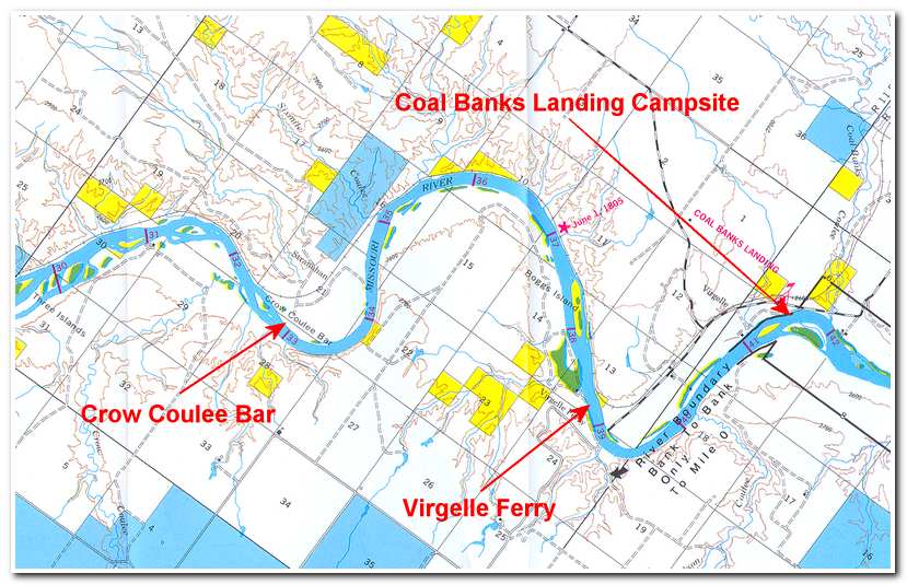
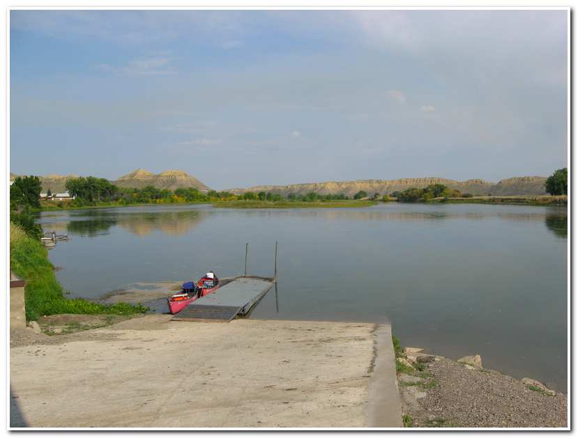
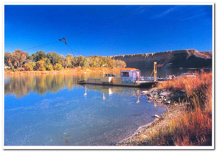
From Crow Coulee Bar I paddle around a sweeping 5 mile long bend past steep cliffs on the left until I reached Boggs Island which I passed on the right (37 miles). About a half mile past Boggs Island I paddled past Virgelle Ferry (37 ½ miles: 3:40). The low hanging cables at Virgelle Ferry make this a potentially dangerous passage. I stayed well to the right of the channel and skirted under the cable near the right shoreline before paddling hard to the left shoreline and landing near the ferry landing for a short rest before continuing on to my proposed campsite at Coal Banks.
Immediately after the passing the ferry the river sweep around a sharp hairpin turn to the left and continued relatively straight for another couple of miles, Past Jackson Coulee (mile 40), with its coal deposits visible in the cliff bands just above the riverbed, before reaching Coal Banks Landing (41 miles; 4:00).
Coal seams can be seen along the river valley slope in many places. As steamboat traffic, on the Missouri, became more active fuel became quite scare. The average boat burned about 25 cords of hardwood or 30 cords of softer cottonwood in twenty four hours of steaming. Timber along the bottoms was soon hard to obtain. Efforts were made to use the local coal, but when it was added to the boiler fireboxes, it only reddened around the edges and refused to burn.
While attempts to use local coal were unsuccessful, Coal Banks Landing still played an important role in Missouri steamboat history. It was the landing point for Fort Assinniboine, near present day Havre, Montana. Assinniboine was established in 1879. Steamboats brought building materials and supplies into Coal Banks for the Fort. By 1886 Camp Otis had been built at the landing to accommodate the 20th Infantry stationed there during the navigation season.
I had completed the 41 miles from Fort Benton in about 6 hours, and averaged over 6 ½ miles per hour. So it was with a sense of accomplishment that I made camp and enjoyed that sunset that evening looking forward to the next day when I would enter the famous “White Cliffs” section of the river.
-
- Fort Benton Montana
-
- Put in at Fort Benton, Montana
-
- Evans Island, 6 ½ miles below Fort Benton

-
- Loma, Montana the confluence of the Marias and Missouri Rivers
-
- Virgelle Ferry, looking upriver
 Section One of the Route Taken on May 31st 2003
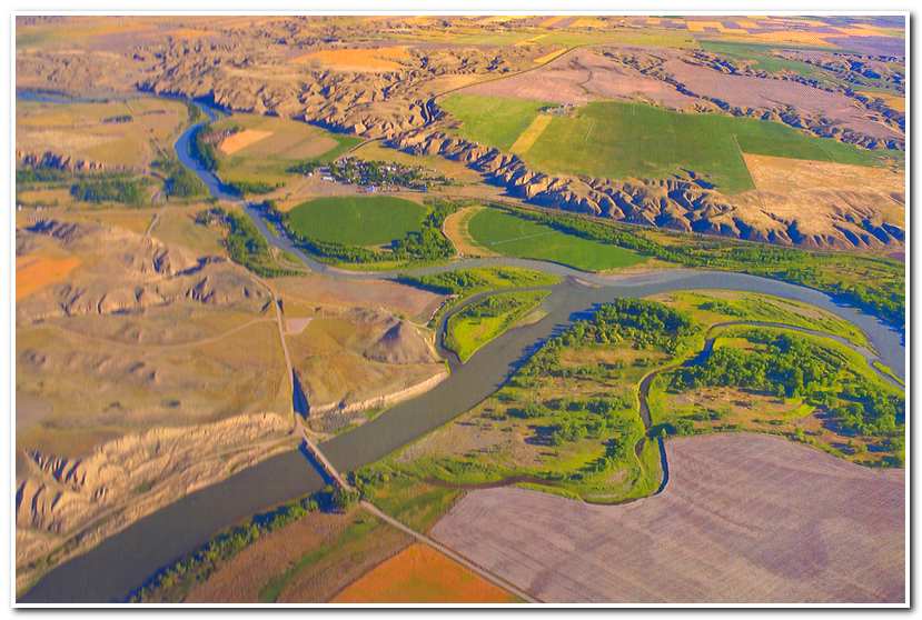
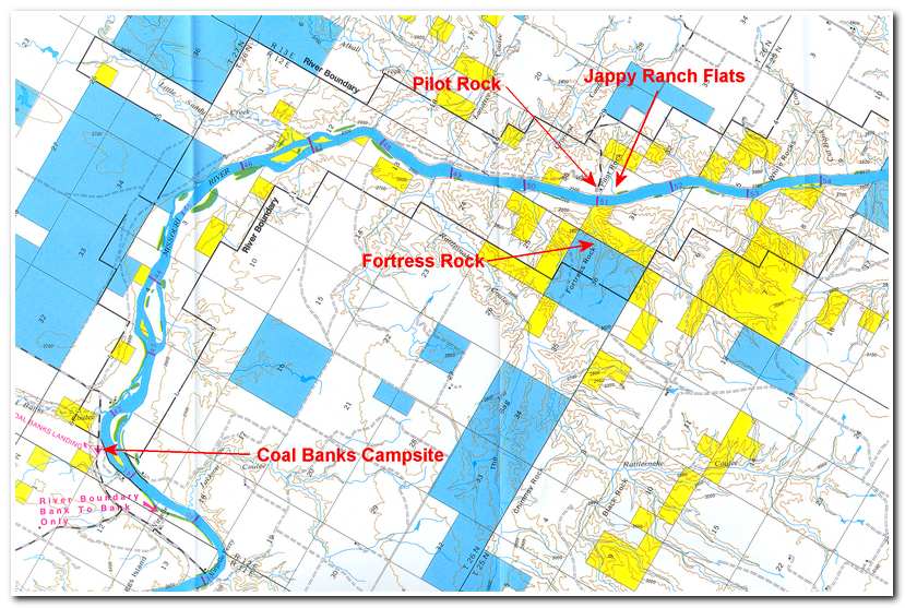
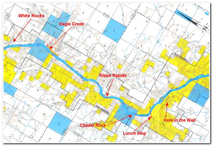
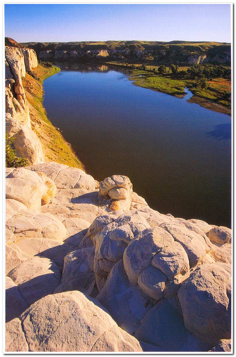
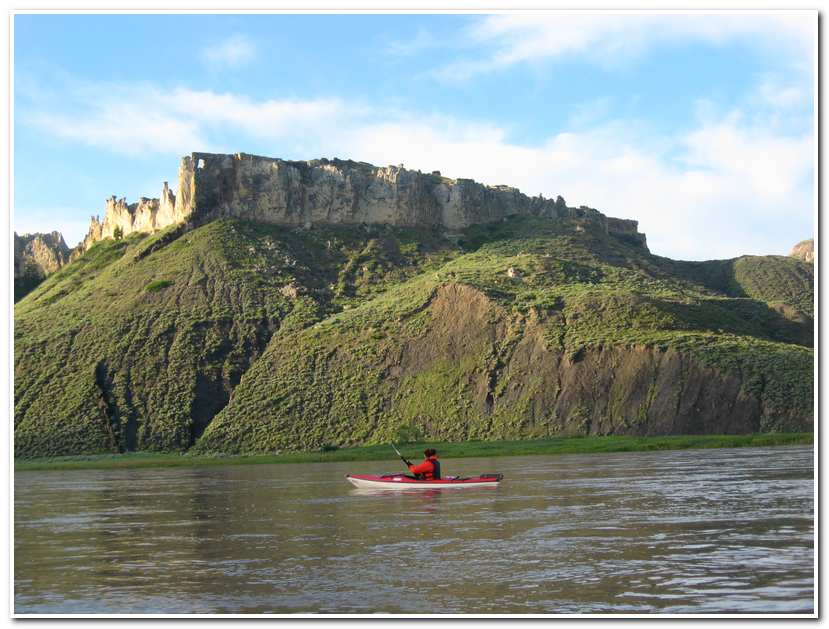
I got an early start the next day (May 31st), was packed and on the river by 6:50. From Coal Banks the river meanders past open land and numerous islands before entering a narrows were the river has cut its path through limestone hills (8 miles). About two hours from camp and ten miles downriver I approached the Pilot Rock on the left and Fortress Rock on the right (10 miles; 9:40). Pilot Rock is a huge boulder in the Jappy Ranch flats along the river and it marks the beginning of the Upper Missouri Wild and Scenic River Area. From here for the next 98 miles the Missouri carves its way through a spectacular series of limestone cliffs that are truly the worth every minute of the long paddle through.
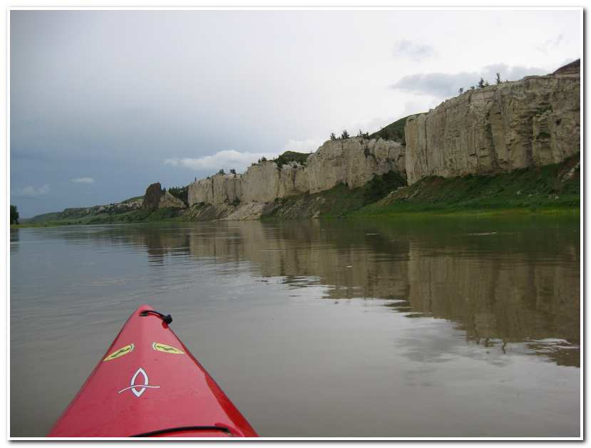
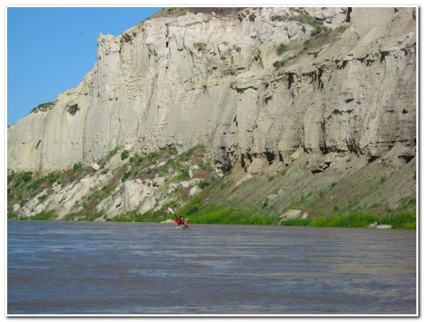
In recording their passage through this stretch of river, Lewis and Clark described “scenes of visionary enchantment.” They wrote of “elegant ranges of lofty freestone buildings, having their parapets well stocked with statuary” and noted “nitches and alcoves of various forms and sizes are seen at different heights as we pass.” They identified erosion as having worn “the soft sand cliffs….into a thousand grotesque figures.” I passed White Rocks Campground on the left bank (12 miles; 9:15), and continued on past Ebersole Bottom (12 ½ miles). This area was used early in the 1860s as a wood supply yard for steamboats. The remains of several buildings still stand sentinel over the river.
 Section Two of the Route Taken May 1st 2003
At mile 14 ½ I passed Eagle Creek, site of Lewis and Clark’s camp of May 31, 1805. Lewis described the scenery as he wrote:
“…..the men are compelled to be in the water even to their armpits, and the water is yet very cold….added to this the banks and bluffs along which they are obliged to pass are so slippery and the mud so tenacious that they are unable to wear their moccasins, and in that situation dragging the heavy burden of a canoe and walking occasionally for several hundred yards over the sharp fragments of rocks….in short their labor is incredibly painful and great, yet those faithful fellows bear it without a murmur….The hills and river cliffs which we passed today exhibit a most romantic appearance. The bluffs of the river rise to the height of from 200 to 300 feet and in most places nearly perpendicular; the are formed of remarkable white sandstone….The water in the course of time in descending from those hills and plains on either side of the river has trickled down the soft sand cliffs and worn it into a thousand grotesque figures, which with the help of a little imagination….are made to represent elegant ranges of lofty freestone buildings, having their parapets well stocked with statuary; columns of various sculpture both grooved and plain, are also seen supporting the long galleries in front of those buildings in other places….we see the remains or ruins of elegant buildings….the tops of the columns did not the less remind us of some of those large stone buildings in the U. States….as we passed on it seemed as if those scenes of visionary enchantment would never have an end; for here it is too that nature presents to the view, of the traveler vast ranges of walls of tolerable workmanship, so perfect indeed are those walls that I should have thought that nature had attempted here to rival the human art of masonry had I not, recollected that she had first began her work…..”
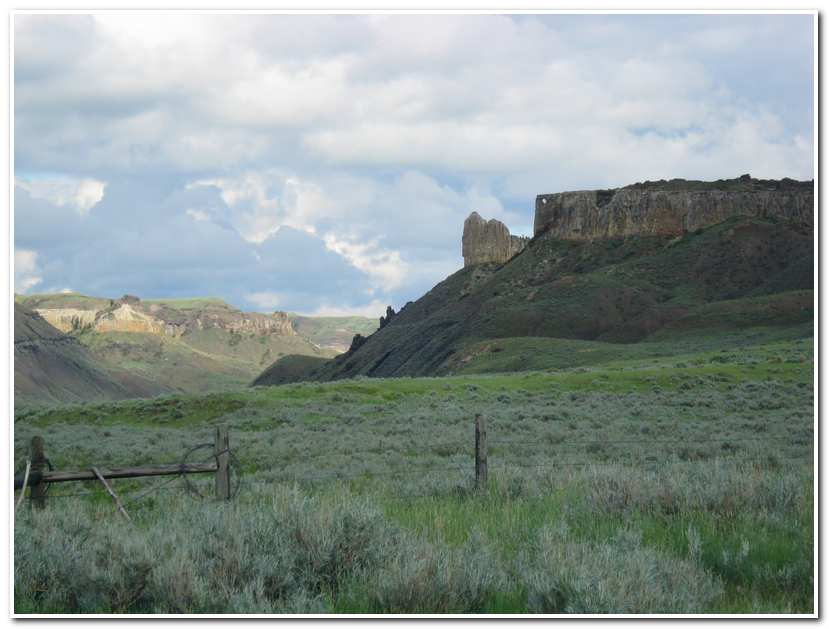
At mile 15 stood LaBarge Rock on the right. At mile 16, on the left bank is the Grand Natural Wall, a thin, fence-like wall of dark rock, that runs from the north perpendicular to the water, falling nearly 100 feet to the river’s edge. At 19 miles I swept past Eagle Rock on the left and on through Kipps Rapids a gentle Class 2 section. Kipps rapids is named for James Kipp who built Fort Piegan, the first trading post in Blackfeet country.
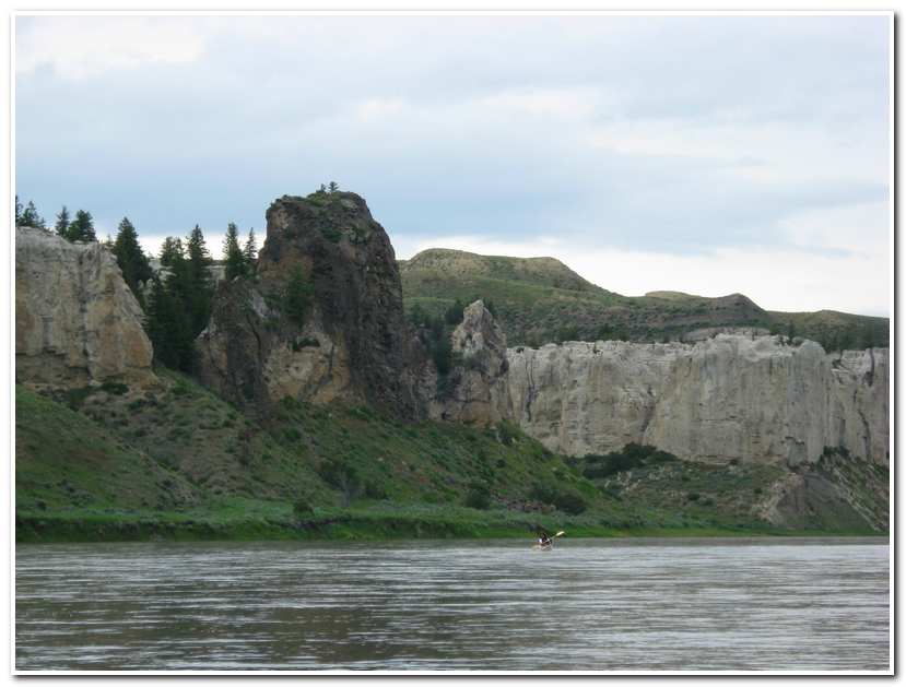
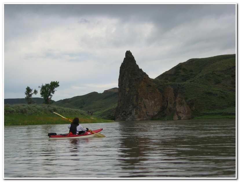
About a mile past Kipp Rapids I came around a corner to the right and had my first view of Citadel Rock, about a mile distant, on the right hand shoreline. Citadel Rock (21 miles; 10:50) is probably the most famous landmark on the upper Missouri and was named by early fur traders who used it as a river waypoint and was immortalized in the well known painting by Karl Bodmer, The rock inspired Prince Maximilian to write on his downriver voyage of 1833, “…we passed the Citadel Rock, to which we bid adieu for ever, not without regret.”
At 11:00 I pulled into the Hole in the Wall Campground (22 miles) and had lunch while taking in the view up river to Citadel Rock and downriver toward Hole in the Wall high in the cliff tops on the right about a mile further on.
 Section Three of the Route Taken May 31st 2003
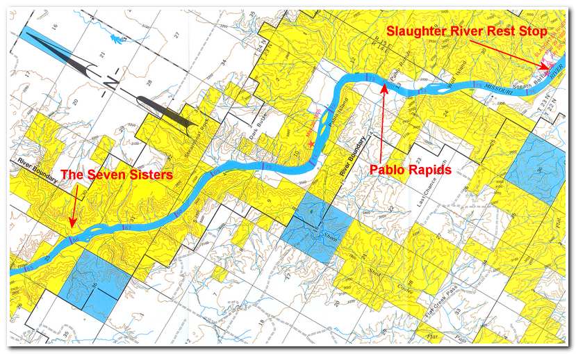
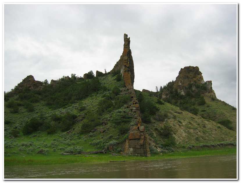
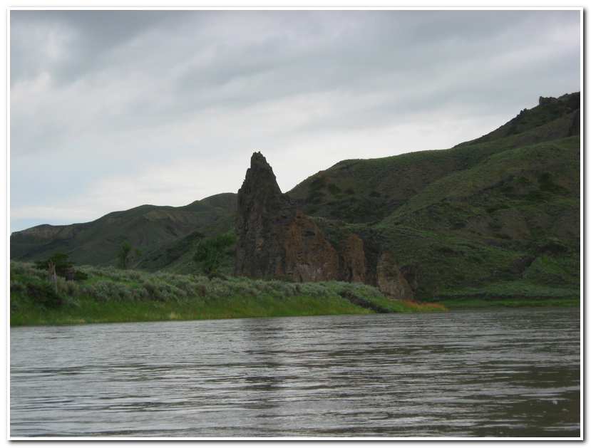
At 11:30 I once again set out and soon passed below Hole in Wall and at 25 miles passed Seven Sisters on the left bank, a multi-columned sandstone formation resembling seven rather curvaceous figures gathered together.
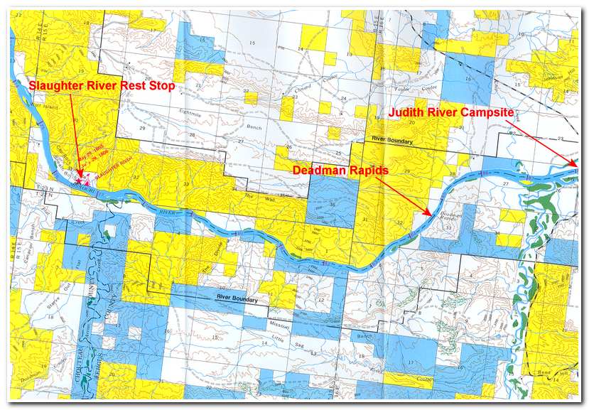
At 1:00 I rounded a sharp bend to the right and was soon traversing Pablo Rapids (32 miles), another Class 2 section of river at added a little spice to an otherwise gentle section of river. After the rapids I pulled in at the Slaughter River Campground for a rest. This is the site of Lewis and Clark’s May 29,1805 camp. Lewis wrote of the site.
“Today we passed…the remains of a vast many mangled carcasses of Buffalo which had been driven over a precipice of 12 feet by the Indians and perished, the water appeared to have washed away a part of the immense pile of slaughter and still their remained the fragments of at least a hundred carcasses they created a most horrid stench…we saw a great many wolves in the neighborhood of these mangled carcasses they were fat and extremely gentle, Captain C. who was on shore killed one of them with his esponatoon. Just above this place we came to for dinner opposite the entrance of a bold running river 40 Yds. wide which falls in on Lard side. This stream we called Slaughter River (now Arrow Creek).”
 Section Four of the Route Taken May 31st 2003
From Arrow Creek the right side of the river was dominated by low rolling hills while the left side rose in sharp high cliffs. One such cliff was aptly named “The Wall” (34 – 35 miles). The river itself remained calm below Pablo Rapids until I reached Deadman Rapids (43 miles; 2:45)
Deadman Rapids was originally named “Ash Rapids” by Lewis and Clark, probably after the ash trees growing near the river just upstream of the rapids. The modern name came about in 1837 a party of men and canoes traveled from the Judith River to Fort McKenzie (at Brule Bottom 14 miles from Fort Benton) to warn the fort manager that smallpox had broken out on the boat bringing up trading goods. The Blackfeet refused to believe the men and demanded the goods be brought upriver. On their return to the Judith, one canoe capsized in the rapids and all four men aboard were drown. The heroic mission was in vain, for within a short time smallpox ravaged the Blackfeet country.
At mile 47 ½, I passed under the Judith Landing Bridge, the first river crossing since Virgelle Ferry 50 miles upstream. The Judith Landing Ferry was put into service in 1887 and crossed the river here until the modern bridge was finished in 1982. I pulled ashore at Judith Landing (3:40) and set up camp in the campground there for the night. It was here that Lewis and Clark camped on May 28, 1805. Lewis wrote in his journal:
“Last night we were all alarmed by a large buffalo bull, which swam over from the opposite shore and….ran up the bank in full speed directly towards the fires, and was within 18 inches of the heads of some of the men who lay sleeping before the sentinel could alarm him or make him change his course, still more alarmed, he now took his direction immediately towards our lodge, passing between 4 fires and within a few inches of the heads of one range of the men as they yet lay sleeping, when he came near the tent, my dog (a Newfoundland named Scannon) saved us by causing him to change his course a second time, which he did by turning a little to the right, and was quickly out of sight, leaving us by the time all in an uproar with our guns in our hands, inquiring of each other the cause of the alarm….”
“….This morning we set out….and passed a handsome river which discharged itself on the Lard side….it appeared to contain much more water than the Muscle-Shell river, was more rapid but equally navigable….the water of the River is clearer much than any we have met….”
This, the Judith River, at first named Bighorn” by Lewis, was renamed by Clark in honor of Miss Julia Hancock, who later became his wife.
-
- Nearing Fortress Rock on the right
-
- Passing Fortress Rock
-
- Across from the mouth of Eagle Creek
-
- White Cliffs
-
- Approaching Citadel Rock
-
- Nearing Citadel Rock
-
- Below Citadel Rock near lunch stop at Hole in the Wall campground

-
- Hole in the Wall (center right)
-
- Looking across the river from Hole in the Wall campground

-
- Passing Hole in the Wall after lunch
-
- Scene below Hole in the Wall

-
- The Seven Sisters

-
- The “buffalo kill” cliffs across from the Slaughter River (Arrow Creek)
-
- Judith Landing
 Section One of Route Taken June 1st 2003
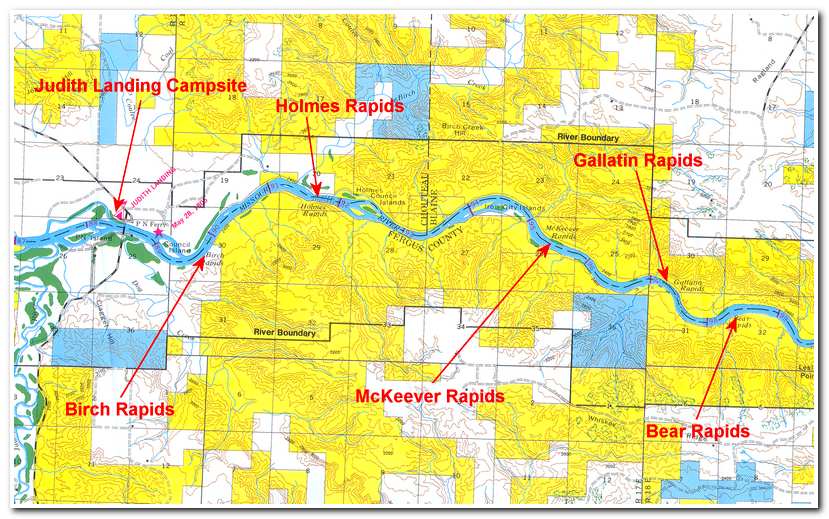
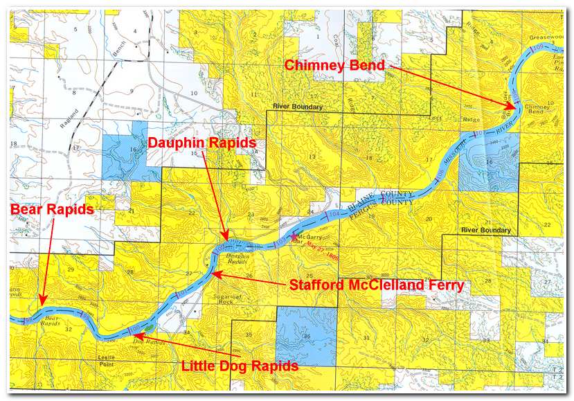
On June 1 I got an early start and was on the river by 7:00. I planned a long day. It is 61 miles from Judith Landing to the pullout at the James Kipp Campground. This section is also known for 13 sets of rapids. Fortunately all but one, Dauphin Rapids are not much of a challenge. Because of the distance I set a faster than normal paddling pace and strove for a 7 mph pace. A short distance below Judith Landing I passed through the first of the rapids, Birch Rapids. Within a half hour I was passing through Holmes Rapids (4 miles) and then past Holmes Council Islands. Four miles below Holmes Rapids I passed through McKeever Rapids (8miles; 8:00). Two miles further on was Gallatin Rapids (8:20). The river narrowed here and the current picked up but overall it was easy going. A short distance on was Bear Rapid: then at 12 miles was Little Dog Rapids, just before the Stafford McClelland Ferry. The ferry has been in service since 1915. Just after the ferry I rounded a right hand bend and was immediately in Dauphin Rapids (14 miles: 8:40). I had established an 8.75 mph pace for the first 14 miles. I think 6 mph was due to the current and I added the rest through paddling steadily and moderately hard. Dauphin Rapids wasn’t too difficult, probably Class 2+.
 Section Two of the Route Taken June 1st 2003
At 15 miles I passed McGarry Bar on the right. This was the May 27, 1805 campsite of Lewis and Clark. Lewis wrote:
“….the bluffs are very high steep rugged, containing considerable quantities of stone and border the river closely on both sides; once perhaps in the course of several miles there will be a few acres of tolerably level land in which two or three impoverished cottonwood trees will be seen….the bluffs are composed of irregular tho’ horizonal strata of yellow and brown or black clay, brown and yellowish white sand, of soft yellowish white sandstone and a hard dark brown freestone, also of large round kidney formed and irregular separate masses of a hard black iron stone, which is imbedded in the clay and sand.”
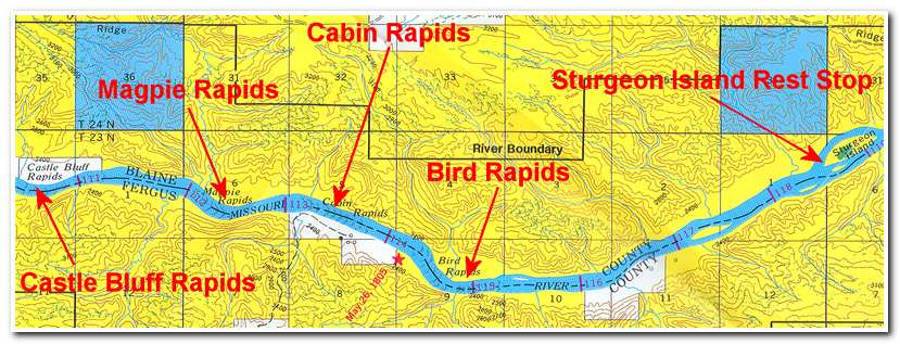
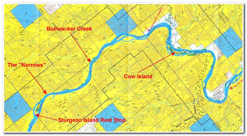
From McGarry Bar it was another 5 miles to Chimney Bend and then the small Lone Pine rapids (21 ½ miles) and the much longer Castle Bluff rapids (22 miles). Then three more rapids in quick succession; Magpie Rapids (24 miles), Cabin Rapids (25 miles), and Bird Rapids (26 miles). At 11:15 I stopped to rest at Sturgeon Island (30 ½ miles, a 7+ mph pace since Judith Landing).
Section Three of the Route Taken June 1st 2003
Below Sturgeon Island the river narrowed down and passed by tall cliffs on the left before emerging into more open ground several miles later. At 34 miles I came to Bullwhacker Creek on the left and at 38 miles Cow Island Landing.
 Section Four of the Route Taken June 1st 2003
The paddling then eases even more as the rugged hills and cliffs are largely left behind and the river begins passing through the more rolling open country of the badlands.
 Section Five of the Route Taken June 1st 2003
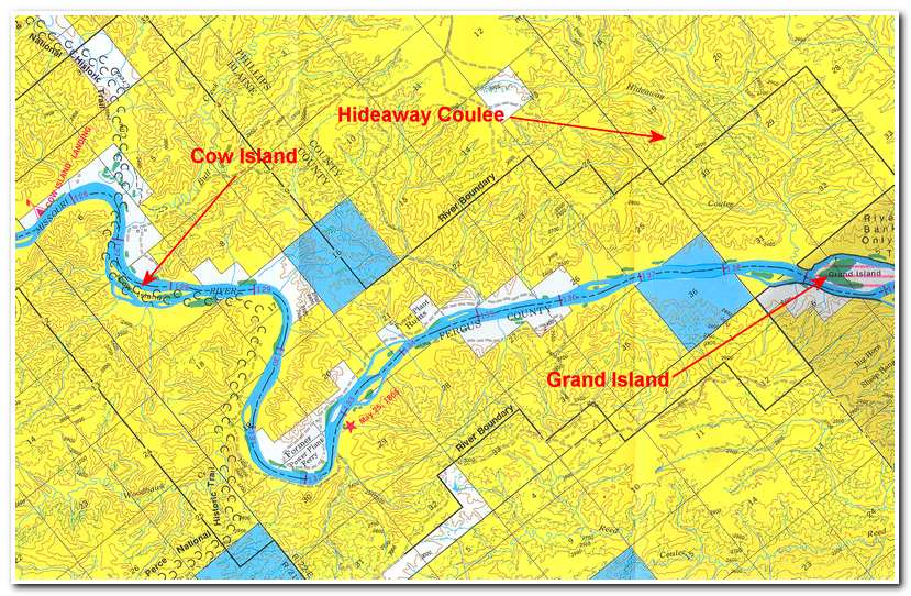
At 51 miles I passed Hideaway Coulee and Grand Island. Kid Curry, and outlaw and ally of Butch Cassidy, The Sundance Kid and their Wyoming Hole in the Wall gang, had a hideout five up the coulee. Curry, and the Wyoming outlaws held up a train at Wagner, west of Malta, Montana, on July 3, 1901. After the robbery, they fled to Curry’s hideaway.
 Section Six of the Route Taken June 1st 2003
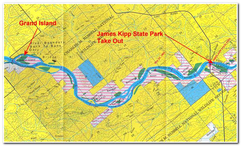
After Grand Island I continued paddling for another 11 miles until I rounded a corner and passed beneath the Robinson Bridge, across highway 191, and landed on the right hand shoreline at James Kipp Campground (61 miles: 4:00; 6.7 mph pace for the day). It had been a long trip but well worth the effort. The variety of the scenery and the multiple rapids had kept it interesting the entire time. Since leaving Fort Benton I had kayaked the Missouri as it flowed across the high plateau near Fort Benton, then as it carved its way through the sandstone buttes of the White Cliffs and finally, as that rugged wilderness fell astern, the rapid strewn section that led into the badlands before reaching the Kipp pull out. I had now completed over 400 miles of river travel since leaving the Three Forks Headwater put in.
-
- The Stafford McClelland Ferry

-
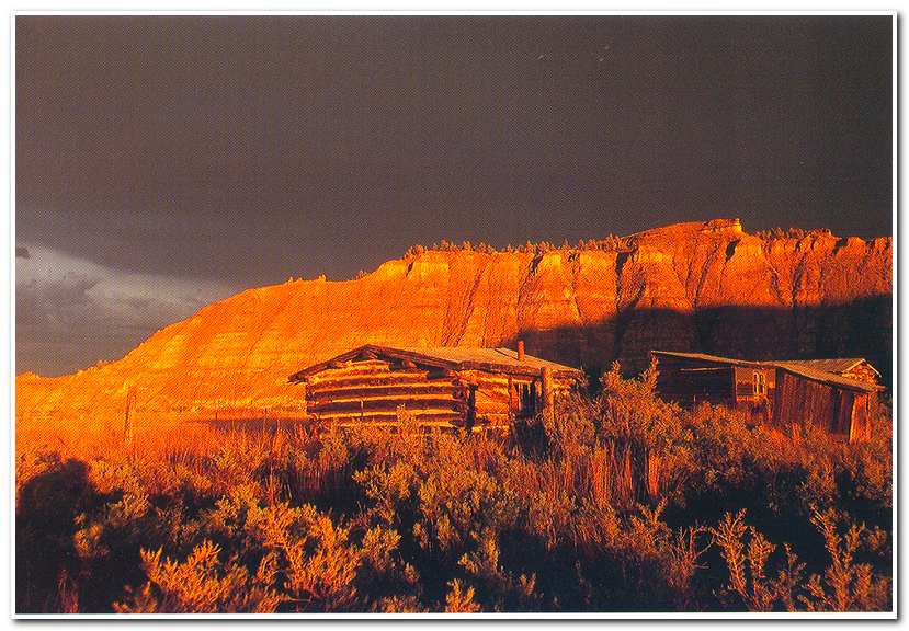
- Cabin at Bullwhacker Creek
-
- Below Cow Island, the river enters badlands country
-
- Nearing James Kipp take out
-
- Passing under the bridge at the James Kipp take out

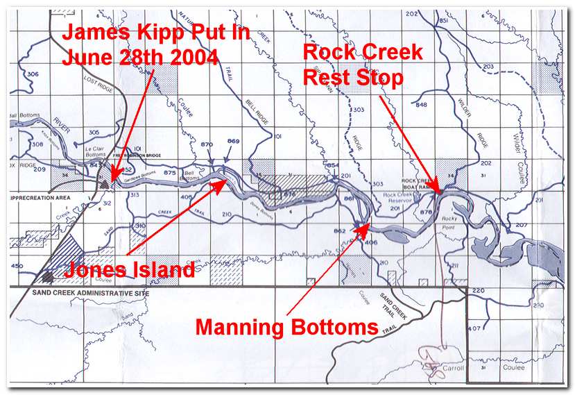 Section One of Route Taken June 28th 2004
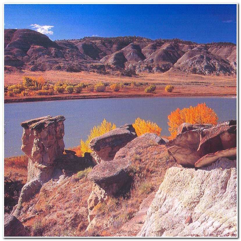
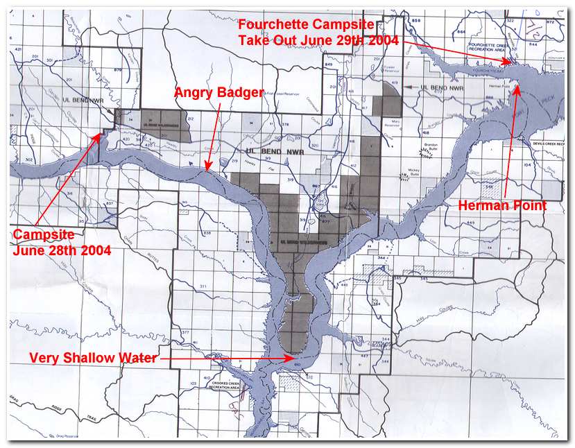
I undertook the next leg of my journey on June 27, 2004 when I drove to Great Falls and met up with John Reese, my relay driver, and headed east to Kipp early the next morning (the 28th). We arrived at the campground at about 10:00 that morning and packed my kayak with the supplies and camping gear I would need for two to three days on the river. The plan was that John would drive around through Malta, spend the next day site seeing and then drive the dirt back roads to Forchette, on the 30th, set up camp and wait for me to paddle into his camp. Since there was no reliable drinking water along the 75 miles of river between Kipp and Forchette I carried nearly four gallons with me in multiple 1 liter bottles. By 10:50 everything was packed and I shoved off and headed downriver. This section has very few access points along its length and a lot of very shallow, braided stretches which made it one of the most problematic one the entire route. When I left Kipp it was still unclear whether there was enough water around the UL Bend area, about 40 miles downstream, to make the passage and I was repeatedly warned about the very dangerous mud flats in that area, so if the route was closed I would have to retrace my path back to Kipps and try again at higher water which could mean waiting several years. However, over the years I have found that locals tend to exaggerate the actual conditions, partially because they themselves don’t know, but want to appear knowledgeable, and partly to inflate their pride in the ruggedness of their local environment (the ‘mountain man’ syndrome).
Between the Kipp put in and Jones Island (4 miles; 11:40) I passed by several groups of fishermen snagging for paddlefish. Snagging is typically done from the shore with surf-casting gear; a large, lead weighted treble hook is cast well out into the river and then reeled in with yanking motions. This prehistoric looking bottom dwellers are apparently good eating and this section of the Missouri is one of the only areas they are to be found. Needless to say I gave these guys plenty of room and was relived when I had passed them by.
At Jones Island the main channel bends to the right. The banks of the river are undercut and erosion is evident along the bottoms. By noon I had passed Doney Bottoms, on the right and was passing White Bottoms on the left. The river currant was moderate, but steady and the riverbanks were lined with Cottonwood trees. I meandered past Manning Bottoms and at 1:15 came to the Rock Creek Recreation area (14.5 miles). Here I pulled out and took a brief rest and water break before continuing on downriver.
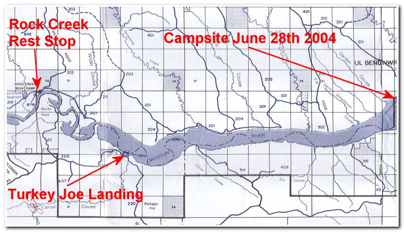 Section Two of Route Taken June 28th 2004
After Rock Creek the river follows a much more braided slow moving path past flat low bottoms. Here route finding was a little more difficult, but not to challenging. At 3:00 I reached Hutton Bottoms and Turkey Joe Boat Ramp (21 miles). From here on I was, in theory Fort Peck Lake, however the water level was so low I was really only following a tortuous path through sandbars and mudflats as I made my way almost due east for another 3 and ½ hours before coming ashore and setting up a camp amongst the shoreline willows at 47. 35.9 N; 108. 01. 10W (35 miles; 6:30).
 Route Taken June 29th 2004
On June 29th I set out at 6:30 after a very restless night in a poor campsite. It was good to be back in the kayak again. A few miles down the river as I was passing close to the left shoreline I heard a rustling in the underbrush nearby. I glanced over and suddenly a very angry badger came crashing out of the willows and snarling and bearing his teeth. It was clear that I had invaded his territory and he wasn’t the least bit happy about it. Fortunately he wasn’t inclined to swim so after a good bit of bluster he disappeared back into underbrush and I continued on my way.
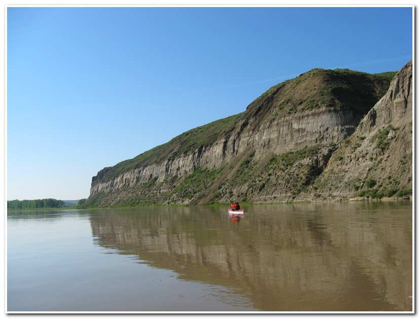
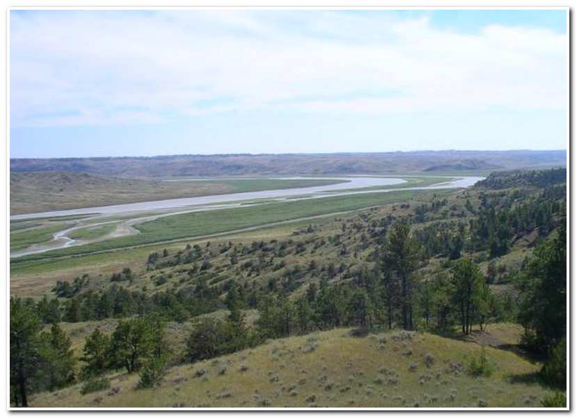
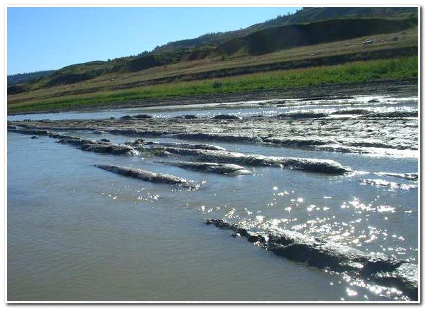
By 8:00 I was heading due south down the west side of UL Bend. I had left the sand bars behind and the river was well defined. The left side of the river was defined by dry scrub brush and sandstone bluffs and the right by rolling arid hills. This pleasant going lasted until I approached the bottom of UL Bend. Very quickly the river deteriorated into a maze mud flats and the depth of the channel varied between 2 and 8 inches. I watched carefully for signs of current and often had to paddle through mud and slime. Once I even followed a paddlefish channel for several hundred yards. Making the UL Bend was a challenge but by 9:30 I had rounded the Bend and the river gradually deepened and the route became a bit easier.
The east side of UL Bend runs roughly north and south and is dominated by rugged cliffs on the left and rolling pine covered hills on the right. I made good time and by 11:00 had gone about 25 miles from camp and was only fifteen miles from Forchette. The river was now truly a lake and a paddled along the left shoreline in the wind shadow provided by the cliff line that tracked the lake shore.
At 2:00 I reached Herman Point. Here I was only a little over a mile from Forchette Campground, but I still had to cross Forchette Bay which was exposed to the northwesterly wind that was blowing. Fortunately the wind wasn’t strong enough to build really serious waves and I was able to make my way along in light whitecaps and 18 inch to 2 foot waves across the bay. I reached the campground at 2:30 in hot bright sunlight. I was pretty dehydrated so I spend the first hour drinking several quarts of water while I set up a campsite. John wasn’t due until the next morning so I spent the evening relaxing and recovering and just enjoying the solitude of my campsite and the sense of accomplishment for having now come 475 miles from Three Forks.
After a restful night and a lingering breakfast I walked around the general area of the campground for a while, waiting for John to arrive. He had spent the night in Malta, some sixty miles of rough gravel road from Fourchette, so I expected that he would arrive about 10:00. Sure enough, at 10:05 John pulled into the parking lot and after a congratulatory handshake we began loading my gear and kayak. By 10:30 we were back on the gravel road headed for Malta. The sixty miles to Malta was through dry scrub and sage brush and every few miles we came across both live and rattlesnakes in the road. As much as it was to count rattlesnakes in the road it was a welcome transition when we finally arrived in Malta and the paved main highway. From Malta we turned east and headed for the town of Fort Peck which was the starting point for the long, 218.4 mile section of the Missouri which ended at the I-85 Bridge, a few miles outside the town of Williston, North Dakota.
 West side of U L Bend
 Mud along the bottom of U L Bend.
Before I describe that trip however, I first need to recount the intervening 74.5 miles section across Fort Peck Lake between Fourchette Campground and Fort Peck Dam.
On July 2, 2003 John Reese and I left Great Falls with my newly acquired river fishing boat and headed east with a plan in mind of completing all the motoring sections of my transcontinental route during that month. The Fort Peck section was first test of this plan. John was going to act as my driver and meet me at the end of each section with the car and trailer and we would then move on to the next motoring section until we reached St. Louis. After that John would be replaced by Jim Nielson who would drive out from Great Falls and take over for the Mississippi River and Ohio River portions of the trip.
After heading out of Great Falls John and I drove east for several hours, through Lewistown and Winnett before coming to Jordon, Montana. Here we turned north and drove 26 miles to the Hell Creek boat launch on Fort Peck Lake. After putting in we left Hell Creek at around 4:00 that afternoon and headed west, up lake for Forchette. We had good weather and calm waters and the 42 mile trip went fast. By 6:30 we were arriving at Forchette and by 7:00 we had our camp set up and were enjoying a cold beer and solitude of this remote arid campground.