Black Horse Racing Header

“If you’re not moving, you’re standing  still.”


Steve Trafton

Alpine Hiking Switzerland, Austria and Italy

Alpine Hiking
Switzerland, Austria and Italy

Sargans to Plockenpass

2006, 2007, 2008

By

Stephen J. Trafton

Looking toward the Forcela Lavaredo and the Tre Cime

Introduction


This book (route indicated by Time-in-a-Capsule-Line ) is meant to be a companion piece to my earlier books The High Route Across Switzerland from Sargans to Chamonix via Montreux 2005 – 2006 – 2007  (indicated by image004 ) and Tour de Mont Blanc – Haute Route from Chamonix to Zermatt – Tour de Matterhorn (indicated by image006 ). It details Alpine hiking Switzerland, Austria and Italy with both a northerly route from Sargans to Malban, Liechtenstein then along the Austrian/Swiss border before turning south to the Giogo della Stelvio near Bormio, Italy and a southerly route from Sargans to Bernina Pass on the Swiss/Italian border thence east to intersect the northerly route at the Giogo della Stelvio. From the Giogo della Stelvio the route continues east to Bolzano, Italy and then through the Dolomite mountains of northern Italy and finally along the Austrian/Italian border to Plockenpass near Slovenia.

image008
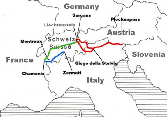
Hiking Route from Zermatt to Chamonix to Sargans to Plockenpass


Northern Route from

Sargans to Giogo della Stelvio

image010
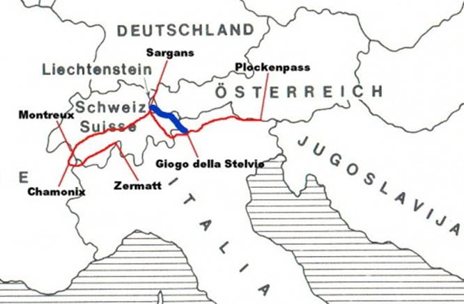
A description of the route taken from Sargans, Switzerland along the Swiss/Austrian border, then southeast to the Swiss/Italian border at Sesvenna Hutte and on to Giogo della Stelvia.


Vaduz to Sargans

image012NOTE: The description of this first section of the northern route to Giogo della Stelvio is unique in that it describes a hike taken in 2006 from Feldkirch, Austria to Vaduz, Liechtenstein and then on to Sargans.


August 2, 2006   Left Sargans on the early train to Feldkirch, Austria and began the long walk alongside the road to Sargans. It was a pleasant day; the walking was easy, if not a little monotonous. A short distance out of town I reached the Austria/Liechtenstein border and continued on toward Vaduz. I soon passed through Nendeln and then Schaan. Several hours after my start I walked into Vaduz. Vaduz is a picturesque town set below mountains to the east and seemingly dedicated to art and music. The central part of town is a large mall lined with statuary, art galleries and bistros. Above it all on the hillside is the palace of Hans-Adam II, the prince of Liechtensteirn.  From Vaduz I continued on the road south to the town of Thiesen and then onto Balzers.  At Balzers I crossed the Rhine River and entered Switzerland at Trubbach before turning south once again to Sargans. The entire walk was along the side of the road, but ignoring that, I passed through several quaint little villages along the way. Late in the afternoon I entered Sargans from the north and reached my hotel, the Zum Ritterhof, in time to enjoy a few cold beers before dinner.


Vaduz to Pfalzer Hutte

image028

July 22, 2007   After meeting up with  my long-time climbing partner Al Errington, we took the train ride from Bad Ragaz north to Vaduz and then hired a car for the short drive to the ski area at Malbun, Liechtenstein. From here we boarded the ski lift to Bim Chrutz (2003m – 6572ft) (1:00p).  Here the hiking started in earnest. The trail to the Pfalzer Hutte followed the ridge top above Malbun with only slight up and downs along the way. The hiking was easy with a good trail. Soon we passed through Sareiser Joch (2000m – 6562ft) and past Spitz (2186m – 7172ft). From Spitz we traversed the ridge to Augstenberg (2359m – 7740ft) where we stopped for a snack and sat next to the old wooden cross on the summit. On the far side of Augstenberg the trail descended slightly to a little col (2308m – 7572ft) before dropping sharply over the last half kilometer to Pfalzer Hutte (2108m – 6916ft) (3:15p).

Pfalser Hutte to Mannheimer Hutte

image034


July 23, 2007
  After a good night’s sleep  we got up at 7:00a, had breakfast and under clear skies started for Mannheimer Hutte at 8:20a. We hiked through heather and boulders on a long gently ascending traverse to Barthumeljoch (2305m – 7562ft). We continued on across grass and heather ascending gradually to Gross Furgga (2359m – 7740ft), a col which crosses the ridge crest below the Hornspitz (2537m – 8323ft). Here the wind picked up to 20 – 35 mph as we went quickly through the pass to the shelter of the lee side. Once through the pass we descended and traversed across steep ground to a second col, the Chlei Furgga. By then the wind was blowing 30 – 40 mph. From Chlei Furgga we traversed the south side of Salarue (2727m – 8947ft) to a third col/ridge crest (2499m – 8198ft). Here we climbed steeply up to 2662m – 8733ft and then started an exposed traverse across very steep rocky slopes. The worst parts were protected with cables so it was not too difficult, but definitely not for beginners. At last we reached the Schaflochsattel (2713m – 8901ft), a col bordering the Brandner Gletscher about a kilometer from the Mannheimer Hutte. We crossed the glacier on a well-marked trail and then hiked up the far slope to the hutte (2679m – 8789ft) (2:00p). That night we were warm and snug in the hutte while a storm passed through.


Mannheimer Hutte to Totalphutte

image054

July 24, 2007  
Tuesday morning, we got up at 7:00a to clear skies and had a quick breakfast before setting out for the Lindauer Hutte. We left at 7:50a and walked down the gravel slope to the edge of the glacier. From here we headed off across the glacier southeast toward a rounded ridge and then on to Schesaplana Sattel (2739m – 8986ft) a col just to the west of Schesaplana (2965m – 9728ft) the dominant peak in the area. We traversed around the south side of Schesaplana on scree ledges and cables to a col at 2837m – 9308ft then descending down steep slopes and ledges to Totalp Hutte (2381m – 7812ft) (11:00a). Al was really suffering from the flu so we decided to stay here for the night and go on to Lindaur Hutte in the morning. We had some thunder and rain but the weather was supposed to be improving.


Totalp Hutte to Lindauer Hutte

image068


July 25, 2007  
Arose at 6:30a the next morning and after a quick breakfast we set out toward the Lindauer Hutte. Al was still feeling pretty punk so we went a little slower than our usual pace. Leaving the hutte we descended the steep rocky trail alongside the supply tram that led to the hutte from below. After about an hour we reached the Lunersee (1970m – 6463ft), a large lake set in the valley below Totalp. Once at Lunersee we traversed around on a track to Lunersee Alpe (Alm) a small farm at the south end of the lake. We then turned onto the RatikonHonenweg Nord (marked 102) climbed gradually alongside a little stream and skirted a marshy basin filled with cotton grass. Eventually the trail ascended to the Verajochl (2330m – 7644ft) (9:50a).

From here we had an impressive view ahead to the great rocky gash of the Schweizer Tor which marks a crossing into Switzerland. From Verajochl we descended grass slopes to the one-time hut near the Schweizer Tor (2137m – 7011ft). The Schweizer Tor was once a Swiss border post, but all that remains is the deserted Customs House. A short way south of the path, a tall yellow sign and a stone obelisk mark the Swiss/Austrian border. From Schweizer Tor we ascended a narrow grassy valley below the Drusenfluh (2827 – 9275ft) and reached Ofapass (2291m – 7516ft) about 40 minutes from Verajochl.  Al was feeling pretty tired so we were happy to see the Lindauer Hutte 3 kilometers away and 500m – 1640ft below in the valley beyond. With the hut in sight virtually all the way, the path descended steeply in places, with the Drusenfluh’s rocky presence growing more impressive with each step. Shortly after passing a small farm in the lower valley we wandered past the farm building of Obere Sporaalpe (1739m – 5705ft) and reached the Lindauer Hutte (1744m – 5722ft) (12:15p).


Lindauer Hutte to Tilisuna Hutte

image084

July 26, 2007 Clear day. Got up 6:30a and had breakfast. Al was feeling better but still not 100%. We started for the Tilisuna Hutte at 7:40a. The trail left the hutte and descended a little toward a stream crossing in the Porzalengawald, a forest near the hutte. Periodically we could see the cliffs of the Sulfluh (2818m – 9245ft). After crossing through the woods we took the path to the Bilkengrat. The trail climbed steeply up the slope passing through a belt of pine trees and emerged to a stunning view back to the Drei Turme of the Drusenfluh. Continuing on toward the Bilkengrat the steep trail continued for another 350m – 1148ft of elevation gain to the Scharze Scharte (Black Pass) (2336m – 7664ft) (9:50a). The view from the pass included the Tilisunasee which lies below in a green basin. From here it was a steep descent down to the Tilisuna Hutte (2208m – 7244ft) (11:00a).

Pages: 1 2 3 4 5 6 7 8 Next »