Black Horse Racing Header

“If you’re not moving, you’re standing  still.”


Steve Trafton

Swiss Alpine Pass Route – Sargans to Montreux

 The Swiss Alpine Pass Route
Sargans to Montreux
2005 – 2006

Sarg to Montreux 2


The Swiss Alpine Pass Route across Switzerland makes a complete east to west traverse from the town of Sargans, on the Swiss border with Liechtenstein, to Montreux on the shores of Lake Geneva and the French border. It passes through 202 miles of mountains and valleys, crosses 16 mountain passes and gains over 59,000 feet in 15 daily stages.

Each day the hiker wanders the trail for hours through valleys filled with wild flowers, streams and waterfalls. Then, after leaving the valley behind, the trail rises up past remote farms, hay barns and pastures to high alpine meadows. Soon the hiker climbs even higher, past mountain tarns, glaciers and past the great peaks of the Bernese Oberland. After reaching one of the many high passes he begins his descent back down into the next valley before stopping for the night at one of the picturesque villages along the way.

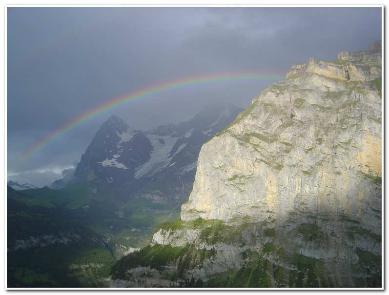
Every one of the passes crossed by the route has its own special character: From the remote, slender crest of the Richetli to the broad, crowded Kleine Scheidegg with its close-up view of the Eiger, Monch and Jungfrau. From the narrow rocky notch of the Bunderchrinde to the open grass saddle of the Blattipass that overlooks the Bernese Oberland. From the Hohturli with its awesome cliffs and glaciers nearby, to the Col de Chaude which overlooks Lake Geneva far below.

It is not only the passes that make this route so memorable, but the villages visited on the way. These add their own character to the trip. After hiking hard all day long you come down, at the end of the day, to delightful little villages like Weisstannen and Elm, to Griesalp or Gsteig. These are flower bedecked villages whose balconies look out at the very mountains you have been hiking through all day.

Sarg to Montreux 3The Alpine Pass Route 2005 – 2006


The Route. The first stage of the route is a fairly easy one that climbs up into the mountains from low-lying Sargans, on the Rhine River. It then works its way southwestward into the wooded Weisstannental, a peaceful valley with little population but for the small town of Weisstannen. I spent the first night there. The next day I made for the head of the valley and ascended the steep trail up over 4000 feet to the Foopass. It was a 7300 foot saddle in a ridge linking the Foostock with Kleine-Schiben, followed by a long descent to the village of Elm in the Sernftal valley.

The Sernftal is hemmed in by remote ridges accessed by hidden hanging valleys. To get from Elm to Linthal the trail ascends high pastureland. It crosses over the Richetlipass north of the Hausstock, a dominant peak that overlooks the next valley leading to Linthal.

From Linthal the trail parallels the road that climbs out of the village and cuts through the former glacial valley of Umer Boden. This is a cattle raising pastureland dominated by the snowy Clariden. Beyond Umer Boden lies the Klausenpass which is crossed by a road leading to Altdorf.

Altdorf is famed as Williams Tell’s town, and a statue in the central square commemorates the folk hero. Just across the valley to the southwest lies Attinghausen, a small village that lies at the foot of the long climb to the Surenenpass (7370 feet). From the pass is a great view of the glaciated Titlis which is visible nearly all the way down to the town of Engelberg.

From Engelberg, the trail ascends to the Engstlensee then over the Jochpass before descending to Meiringen, site of Reichenbach Falls, of Sherlock Holmes fame. Meiringen also marks the beginning of the Bernese Oberland portion of the route. From here to Gsteig these fantastic mountains dominate the scene.

Grindelwald is the next goal and it is reached by way of a valley walk alongside the beautiful Engelhorner stream before rising to Grosse Scheidegg, a broad grass covered col leading to the famous alpine village of Grindelwald at the base of the Eiger.

The walk from Grindelwald to Lauterbrunnen by way of Kleine Scheidegg is a world classic. The route passes the Eiger, Monch and Jungfrau as it crosses over the pass and descends steeply past the village of Wengen. It then extends further down to the valley floor to the village of Lauterbrunnen.

From Lauterbrunnen the trail ascends to the cliff side village of Murren and then continues up past the Schilthorn to the Sefinenfurke. After passing through the Sefinenfurke, the route makes a very steep descent on its western side into the Kiental. Here fixed cables on scree slopes provide security until the trail eases, crossing beautiful heather alps and at last enters the little enclave of Griesalp.

The next stage crosses the Hohturli and is one of the most challenging on the entire route. At 9110 feet it’s the highest col. The ascent is up a valley and then the steep scree slopes into a series of rocky spires. After weaving a route through these spires a final steep laddered ascent leads to the rocky cleft just below the Blumlisalp Hut. After resting here the day ends with a tortuous 5250 foot descent to the town of Kandersteg.

From Kandersteg to Adelboden the trail crosses the Bunderchrinde, a narrow passage through a craggy ridge. This is the final rocky pass of the route and one of the most scenic.

The next stage goes from Adelboden, where there is a fine view of the Wildstrubel, which remains in sight for part of the walk on the next stage to the Hahnenmoos and Pommernpass and then down to the town of Lenk.

Two passes are crossed the next day. The first of these is the Truttlisberg which leads to the village of Lauenen. Then the trail continues on over the wooded Krinnen Pass which provides the first views of Les Diablerets before descending to Gsteig.

So far, most of the route from Sargans has led in a southwesterly direction, but on leaving Gsteig the route veers away from the Bernese Alps and heads due west. It first heads up the Blattipass then across a pastoral landscape before winding down to the village of Col des Mosses.

The final leg of the route meanders along the shores of Lac de l’Hongrin, and then ascends to the Col de Chaude. From there Lake Geneva can be seen nearly 4000 feet below. A final combination of forest path, track and service roads descends to Montreux and the end of the route along the shore of the lake.

July 22, 2005 Sargans to Weisstannen

Sarg to Montreux 4

I left from the Hotel Rose in Sargans (8:15; ca. 1580 feet) and walked to the Hotel Ritterhof near the train station. Here I took a path that led behind the hotel alongside the railroad tracks and continued past a residential area before going down some steps, crossing under the tracks and emerging on the short road to Mels (9:15). After continuing to the town square I crossed the River Seez which descends from the Weisstannental. After several minutes I cut left up the steeply climbing track to St. Martin (1880 feet). After passing a small chapel the road forks; the trail follows the left branch. A short distance past the first hairpin turn the trail breaks away to the left and climbs through the woods. I continued on the trail and road to a junction identified as Tschess (10:30). I took the left hand track marked to Weisstannen. At the little village of Schwendi I came onto the valley road and turned right following the road into Weisstannen (12:15; 3240 feet).

Weisstannen is an active farming community. The small church, dedicated to St. John the Baptist dates from 1665. Even though it was raining and my first short day was a wet one, it was good to be on the trail and in the mountains!

July 23 2005 Weisstannen to Elm

I left the hotel at 7:50 the next morning and walked up through the village to a signpost which pointed out the trail to the Foopass. Once out of Weisstannen I followed the road up-valley on the south side of the River Seez. Though the valley was mostly wooded the forest, as I gained altitude it gave way to pastureland and farms. Soon the mountains came into view ahead. Waterfalls and streams drained the hillsides and feed into the Seez, which flowed parallel to the road.

I continued following the track past Alp Vorsiez (8:40), a small restaurant/dormitory. From here I stayed on the road and continued past Glatti (9:10) and up to the end of the road near a remote farm house. A farm track then led up another 2.5 km to Fooalp (6150 feet), and there were several barns and a hut in the high valley below Foopass.

Sarg to Montreux 7

From Fooalp the trail led across a boggy area to a grassy rib that ascended to Foopass (12:00 noon and 7300 feet) about 1150 feet above Fooalp.

Sarg to Montreux 8Signpost at Weisstannen showing Elm to be 8 hours distant


Sarg to Montreux 9Farm at Fooalp


Sarg to Montreux 10Foopass; 7300 Feet


On the western side of Foopass the path dropped steeply at first in switchbacks. Then it dropped more gently and about a half an hour after leaving the pass I walked past Raminer Matt (12:50; ca 6220 feet).

Sarg to Montreux 11Raminer Matt, below Foopass on the path to Elm


After another fifteen minutes of walking along a farm road I came to a second farm (Mittler Stafel) and started along a good farm road that worked its way down through the forest and alongside meadows, crossing side streams as it descended. Eventually I came to a road which led, in long loops, down to the village of Elm (ca. 3150 feet).

Elm is an attractive little community whose houses are flower decked. One of those was Suworowhaus named for the Russian general who stayed here in 1799. Italinsky Suworow was a seventy year old retired Russian general living in Moscow when he was recalled by the Russian Emperor and dispatched to Italy to help the Austrians against the French. Winning three quick battles he was then ordered to Switzerland to aid General Korsakoff in his attempt to drive back more of Napoleon’s men. It was September when Suworow and his 22,000 battle-weary soldiers marched across the St. Gotthard Pass. They were met with fierce opposition in the Schollenen Gorge where the French were lying in wait. A heavy three-day battle ensued, and on the night of the 27th the French destroyed the Devil’s Bridge and retreated. The Russians pushed on down to Altdorf and Fluelen on Lake Lucerne. But as the French had seized all the boats, Suworow was forced to change direction, crossing the Chinzig Chulm (near the Klausenpass) and descending into the Muotatal.

Once more the French were waiting and the Russians were forced into combat on the 1st of October before turning east and fighting their way over the Pragel Pass to Glarus. Here again the French blocked their way, so Suworow turned south up the valley that leads to Elm. A night was spent there, and then they continued up the valley to cross the Panixer Pass (ca 7895 feet) between the 6th and the 8th, where the remnants of his army were caught in a blizzard as they descended above Alp di Pigniu. Hundreds of his exhausted soldiers fell to their deaths, as did countless pack animals. Five days later, when they finally crossed into Austria to reach the remains of Korsakoff’s army just 14,000 of Suworow men remained.

Sarg to Montreux 12A short rest on the trail down to Elm


Sarg to Montreux 13Nearing Elm after crossing Foopass


Sarg to Montreux 14Old graveyard at 15th century church in Elm


July 24 2005 Elm to Linthal

Sarg to Montreux 15

After overnighting in Elm at the Gasthaus Sonne I took a short bus ride up the Sernftal Valley to the farm of Erbsalp (9:30). From the end of the road I walked up a cattle churned muddy path for about a half hour. I came to a large rock beside the trail with a blue and white way mark indicating a mountain path up the nearby Karpf (ca. 8850 feet). Its summit crowns the ridge to the north.

Beyond the rock I crossed a stream marking the head of the valley and began climbing south-west in a series of switch-backs up a grassy spur to a saddle at about 7070 feet. Once through the saddle I descended several hundred feet into a hidden alp with a stream running through it. Here there was a lone building (Wichlenmatt; 11:00). Beyond the hut the trail crossed the alp following a stream upward toward Richetlipass (11:30; ca.7420 feet). The last portion of the climb was quite steep and the narrow saddle that is the pass offered a great view down into the valley of the Durnachtal.          

The descent from Richetlipass was very steep on a narrow twisting path that was quite slippery from the recent rains. As I descended, the path gradually improved until I reached a small hut on a hillside spur. After this the path dropped to a moraine crest and was a pleasant walk along the crest to its end. There was a steep descent, along its right side through several large rocky crags, and it was protected by a fixed chain.

Sarg to Montreux 21The trail leading down the moraine crest before dropping into the Dornachtal


Finally, after an hour and a half descent from the pass, I arrived at Durnagel stream near the farm of Unter Stafel (1:00; ca. 4550 feet). Just beyond the farm, a track to the right crossed a dam/bridge and continued down the valley. Even though the paved road went all the way to Linthal I cut off onto a trail at a sign that read Linthal Bachweg. This trail cut through a sloping meadow to the left and then descended steeply through the woods, eventually arriving at a stream where I took a short rest. After resting I continued down the trail and through a tunnel which  had been blasted through rock. I then arrived back at the paved road into Linthal (ca. 2125 feet). After checking into the Hotel Raben I walked around town and listened to the local alphorn players entertain at the Hotel Adler at the far end of town.

 July 22 2005 Linthal to Altdorf

Sarg to Montreux 22

I left Linthal by post bus at 9:10 on the morning of the 25th for a short ride up to the Urner Boden Valley and then started hiking across the valley toward the Klausenpass. At 9:35 I walked past the small farm village of Urnerboden (ca. 4500 feet) before starting the steep ascent via road and trail up to the pass. About 1.5 km from the town, just after the first hairpin turn, the trail leads up a grassy bank to the left as a short-cut to the next level of road. From there the trail leads from level to level of road ever higher with one particularly long open hillside stretch (ca. 5900 feet) that provided a great view down the Uner Boden Valley. Shortly after this stretch, the trail climbed pleasantly through high pastures to Klausenpass (11:40; ca. 6390 feet). From the pass it was a long hot walk down the road to Unterschachen (2:00; ca. 3230 feet). Just after reaching Unterschachen a big thunderstorm rolled in and a serious rain storm began, so I opted to take the bus the last few kilometers into Altdorf (3:50; ca. 1460 feet).

Altdorf is the capital of Uri canton and is celebrated as the birthplace of William Tell. There is a large bronze statue by Kissling dated 1895 in the main square, the Rathausplatz, on the site where, according to legend Tell had to shoot the apple from his son’s head.

Sarg to Montreux 27

From the William Tell Statue in Altdorf (9:00) it was a short bus ride to the village of Attinghausen (9:15), just across the Reuss River from Altdorf. The cable car was unmanned and the operator had to be called at the middle station and told “I want “bergfarht, bitte”.  At the top station of the cable car there was the small hamlet of Brusti (ca. 5000 feet) and a sign giving direction to Surenenpass. The trail led past a few houses and along a short vegetated crest bright with alpenroses and stunted pines. Then a short rail-guarded section descended a little and eventually led to Grat (10:15; ca. 5970 feet). The views must have been great but unfortunately it was very foggy and all this section of the trail was done blindly.

About 45 minutes past Grat and after continuing to follow the green crest I came to a signpost in a saddle marked as Angistock (11:00; ca. 6660 feet). The fog began to part now and I could see the pass across a long scree slope. The path left Angistock and descended slightly over a rocky area and then crossed over scree and snowfields before rising sharply to Surenenpass (11:50; ca.7515 feet). The view to the west of the pass was spectacular. It is dominated by the Titlis (ca. 10620 feet). A short distance beyond the pass the Seewan tarns lay in the high alpine pastures below.

From the pass the route went left and then down through pastures, just above the tarns, and in another hour or so brought me to Alphutte Blackenalp (1:05; ca. 5815 feet). Here the path continued along a farm track and passed through a natural ‘gateway’ and crossed the Stierenbach on a stone bridge before breaking into an open section of the valley. In another 20 minutes the trail re-crossed to the right bank of the stream and came to a trail junction. From the junction the trail continued down the left fork near a waterfall and meandered down to Berggasthaus Stafeli (2:15; ca. 4570 feet). The final section of trail led downhill for another 30 minutes to the Restaurant Alpenrosli (2:30; ca. 4125 feet). After having a late lunch I caught a 3:00 bus down the valley to Engelberg (3:30; ca. 3300 feet).

Engelberg is a major mountain resort area that was originally developed around a huge Benedictine monastery founded in 1120, and then rebuilt after a fire in the 18th century. The monastery was named by Pope Calixtus II, Mons Angelorum, from whose German form Engelberg was derived.

July 27 2005 Engelberg to Meiringen

Sarg to Montreux 35

I left my hotel in Engelberg (ca. 3300 feet) at 8:40 the next morning and walked to the gondola which took me up, out of the valley to Tubsee (9:00; ca. 5890 feet).. From the top of the lift it was a nice walk around the Tubsee to the base of another lift that went up to the Jochpass. I opted to hike up under the lift for about an hour and reached the Jochpass (10:10; ca. 7240 feet.). Even though most of this section of trail was either on, or under ski lifts, the view from the pass of Titlis and the mountains to the west was great. The overall hike was much better after leaving the pass and descending to the west toward the Engstlensee (ca. 6700 feet).

The Engstlensee lies within a meadowed valley. Its south bank rises steeply to peaks and hanging glaciers of the Wendenstocke which extends on a ridge running from Titlis. The lake itself is crowded with tourists and is accessible by road. I walked down from the pass and along the lake, arriving at Engstlenalp at 11:30. From there it was a short bus ride down to Meiringen (ca. 1959) and the end of Stage Six.

Sarg to Montreux 42

I left Meiringen at 7:55 the next morning and took a short bus ride out of the valley to the top of Reichenbach falls and the start of the Reichenbach river valley. At 8:25 I reached the Berggasthaus Kaltenbrunnen (ca. 3970 feet). The trail was gradual and followed the Reichenbach River through alternating forests and meadows west toward Grosse Scheidegg. Along the way I passed Gschwantenmad. A small farming community and enjoyed a good view of the Rosenlaui Glacier and the Wetterhorn dominating the head of the valley.

The Wetterhorn (ca. 12159 feet), the fabled ‘peak of Tempests’ is one of the most famous and easily recognized mountains in the Alps. There are three main summits: the Rosenhorn (12100feet), the Mittelhorn (ca. 12150 feet) and the Hasli Jungfrau (ca. 12140 feet).

At 9:10 I reached the Hotel Rosenlaui (ca. 4480). The trail then climbed steeply up on the left hand side of the stream for another two and a half hours before reaching Grosse Scheidegg (11:50; ca. 6435 feet), or ‘great divide’. The weather was clear and warm, in the eighties, and the views of the Eiger and the Monch were classic. I had lunch at Grosse Scheidegg and took the high trail around the north side of the Grindelwald Valley to the Berggasthaus First (ca. 7107 feet). From First I took the tram down to Grindelwald (ca. 3390) and checked into the Gletschergarden Hotel and spent, what was left the afternoon sitting on the veranda of the hotel, drinking beer and having a fine cigar while enjoying the view of the north face of the Eiger across the valley.

July 29 2005 Grindelwald to Lauterbrunnen

Sarg to Montreux 52

After spending a night in Grindelwald and visiting with Thomas Luck and his wife whom I met on the trail in Meiringen and then again at Tom’s Cabin in Grindelwald I set down the hill from Grindelwald to Grund about a half mile distant. I then took the tram from Grund to Mannlichen which sits atop the ridge that separates Grindelwald from Wengen and the Lauterbrunnen valley. From the top station of the tram, there is a world class walk along a trail to Kleine Scheidegg (10:45; ca. 6760 feet). This trail provides a spectacular view across to the Eiger, the Monch and the Jungfrau and is one of the highpoints of the trip from a scenic point of view.

After pausing at Kleine Scheidegg to take in the view I continued west toward Wengen and the Lauterbrunnen Valley. A short distance downhill I came to Wengernalp (11:05, ca. 6000). After passing through several pastures and small forested areas I entered Wengen (ca. 4185) about an hour later.

Located on a wide terrace about 1600 feet above the Lauterbrunnen valley, Wengen is a popular tourist-visited and car free town, with great views over the classic carved glacial valley below, and to the Jungfrau, Mettighorn, Briethorn and Tschingelhorn at the head of the valley. The descent the rest of the way from Wengen to the valley floor was steep and hot and I was glad to finally arrive in Lauterbrunnen (ca. 2615 feet) at about 1:00 in the afternoon. From there I took the funicular train up to Murren (ca. 5372 feet) located on top of the 2760 foot cliff that is to the west side of the Lauterbrunnen Valley. Once in Murren I checked into the Hotel Alpina right on the cliff edge and enjoyed the view along with a few liters of the local beer.

July 30 2005 Rain day, no travel.

July 31 2005 Lauterbrunnen to Griesalp

Sarg to Montreux 59

I left Murren at 7:45 on a cloudy damp day, but the rain that persisted all day on the 30th had past and so I pressed on. I took the trail out of town up toward Blumental and reached the Pension Sonnenberg (8:20; ca. 6035 feet. From there it was about ten minutes to Pension Suppenalp (8:30; ca. 6075 feet). A path then led to up and around a brushy spur and on to Shiltalp (9:00; ca. 6390 feet), a collection of cheese makers’ huts. A short distance past the huts I was joined by a Swiss mountain dog out wandering the trail. She followed me over another steep brushy spur and on to the Rotstock Hut (10:15; ca.6690 feet), where I stopped and had hot soup before continuing alone on up the trail toward the Sefinenfurke, the pass that leads to Griesalp.

After the Rotstock Hut I hiked up through a large basin of grass and rocks and over old moraine banks. The last part of the trail ascended steep switchbacks over shale scree before finally arriving at the Sefinenfurke (12:15; ca. 8595 feet).

The weather at the Sefinenfurke was foggy and cold so I wasn’t able to enjoy the view but it was a relief to have crossed one the highest passes on the route. The descent involved several sections of fixed cables and countless timber steps which crossed steep shale scree. After about an hour I came to the farm of Ober Durrenberg (1:30; ca. 6540 feet). Here I enjoyed a cup of hot soup and the old farmer that owned the place repaired my severely cracked walking stick with cow hoof mending tape. Thus fortified I continued on down a steep hillside and an hour later reached Burgli (2:30; ca. 5300 feet). From there it was a short hike down to Griesalp and the Berggasthaus Golderli (3:00; ca. 4725 feet). This had been a long day but was only a taste of the next stage, over the Hohturli to Kandersteg.

Sarg to Montreux 64

The next morning I left the Berggasthaus Golderli at 7:15 and walked down into Griesalp. A signpost near the Berggasthaus Griesalp pointed out the start of the trail which climbed up out of the valley on an old farm road through woodland. In a little while the trail passed Untere Bunalp (ca. 5545 feet) and then continued up to another shelf and pastureland before coming to Ober Bunalp (ca. 6035 feet). From there I kept along the road for a few more minutes and then cut off to the right over rough pastureland to a steep slope of moraine deposits. I worked my up over slippery black grit and clay on a steep slope that was also eroded heavily by rain. I gained altitude quickly until the moraine ended on a rock ridge. The trail then made a short rising traverse around the ridge before the ascent steepened again at last coming to a long section of fixed cables and steep timber steps which rose sharply before emerging at the Hohturli (10:35; ca. 9110 feet). From the pass I walked up a short distance to the Blumlisalphutte (10:40; ca. 9315 feet). Here I rested and enjoyed the view of the Blumlisalp (ca. 12,018 feet) which rose above the hut, to the south, and back across to one last view of the Wetterhorn and Schilthorn to the northeast.

After a quick snack at the Blumlisalphutte I began the descent toward Kandersteg. The way down to Kandersteg started off as a well graded path which switch backed down over broad slopes of scree, then followed a balcony with a spectacular view of hanging glaciers. After descending still further I came onto the crest of a moraine wall, before veering to the right into a rough bowl of pastureland littered with rocks and boulders, at last coming to the huts of Ober Bergli (12:35; ca. 6471 feet) where I stopped for some soup and a beer.

Shortly after Ober Bergli I came to the edge of a cliff overlooking the Oeschinensee. Here I descended a rocky stairway with fixed cables and at the foot of this descent came to Unter Bergli (ca. 5795 feet). From here I went right, and contoured high around the north shore of the lake.

Toward the western end of the lake the trail once again descended to the lakeshore itself. A little further on I came to Oeschinensee (ca. 5225 feet). From here it was a short hike across pastureland to the tram station and a gondola ride down to Kandersteg (3:00: ca. 3860 feet). I found lodging at a grand old hotel, the Ritter Victoria and settled in just as the skies once again turned threatening and the rains started.

Kandersteg marked the end of the traverse for 2005 as rain continued for several more days and so I vowed to return the next year to finish the route.


 The Next Year

June 29 2006 Kandersteg to Adelboden

Sarg to Montreux 74

I returned to Kandersteg in 2006 determined to finish the Alpine Pass Route across the Swiss Alps. On June 28th I arrived in Kandersteg and checked into the Ritter Victoria once again. On the 29th the weather was partly cloudy and about 60 degrees, perfect for hiking through the mountains.

I left Kandersteg at 9:00 and walked along the road past the Bahnhof (train station) and followed a small road left which followed the railroad tracks heading south. The trail soon veered right under a bridge crossed the River Kander and went along a narrow road toward the landing site of the Kandersteg paragliding center. From here a path continued along the river and soon came past the international scout camp. Just after the camp the trail broke to the right and across the meadows. From the meadows the path rose steeply to a road. After crossing this I continued through more woodland before coming onto the road once more. After following the road for another 6 – 7 minutes it made a right-hand hairpin, at which point I went on a way-marked path rising above the Alpbach stream. This path rejoined the road at another hairpin turn where again I followed the way-marked path climbing through a narrow gorge and out into the open pastures of Usser Uschene (10:20; ca. 5077 feet).

I continued ahead across the pasture keeping below the main alp buildings. At the far end of the pastures I came to a junction of farm tracks and took the upper right option that switch backed uphill. Just before it came to an alp building about 30 minutes from Usser Uschene I cut left on a path which climbed toward a band of grey cliffs.

The path swung to the left and crossed a stream and then climbed steeply up through the cliff band on a fault line before cutting to the right over boulder slopes. A short time later I came to the group of three huts Alpschele (ca. 6870 feet). The path then rose between the buildings and traversed to the right across an increasingly stony hillside, before winding up to a junction of paths and a signpost on the edge of a broad slope of scree. The trail then slanted upward across the scree and soon came to the Bunderchrinde (ca. 7822 feet).

As I sat in the foggy narrow cleft of the Bunderchrinde having a celebratory cigar I heard alphorn music drifting up from far below on the Adelboden side of the pass. The ‘concert’ lasted about 20 minutes with two alphornists seeming to be locked in a competition, one echoing the other before launching into his own opus. This was one of those once-in-a-lifetime moments of perfection.

The descent began steeply and took me along a switch-backing path over steep scree slopes to a grassy bluff and high pasture before descending to a farm road which soon brought me to the Berghaus Bonderalp. As it turned out this was the home of one of the alphornists I had heard up on the mountain and so I had a chance to thank him in person for the recital.

After a snack of soup and local beer I walked on down, in a thunderstorm, to Adelboden and checked into the Victoria Eden Hotel.


June 30 2006 Adelboden to Lenk

Today was to be a relatively easy one that started with a descent back down from the center of Adelboden to the valley station of the Silleren (9:00; ca. 4130 feet) gondola. I took the lift to the top station at Sillerenbuhl and then walked a very pleasant one hour along the ridge that connected the Sillerenbuhl with Hahnenmoospass (11:00; ca. 6415 feet).

From Hahnenmoospass I continued left along the divide and followed that path around the hillside towards the lump of the Regenboldshorn. After about twenty minutes I hiked up the last few feet to the Pommernpass (11:25: ca. 6740 feet). The descent from the pass was left over steep pastures, passing hay barns and farms, and through a small forest. This trail continued the Simmenfalle, a spectacular waterfall which trail descended steeply down to the Simmenfalle Restaurant at Oberried (12:45; ca. 3615 feet). From here I rode the bus a short distance into Lenk (ca. 3500 feet).

July 1 2006 Lenk to Gsteig

Sarg to Montreux 86

The hike began with a tram ride up from Lenk (8:35; ca.3500 feet), in two stages to Leiterli (9:15; ca. 6375 feet). From the Leiterli tram station a sign marked the path to Lauenen which rounded the little hump ahead to pass a small col where it then continued on the south side of the ridge. A signpost then marked the trail to the Truttlisberg Pass. The trail cut below the Stubleni peak above the spiny limestone ribs at the head of the Wallbach valley then followed the rocky ridge of limestone boulders and craters to the pass (10:15; ca. 6685 feet).

From the Truttlisberg Pass the trail went left to follow a slightly rising path to another junction, then began the actual descent through eroded fields of wild azaleas and came to the farm buildings of Vordere Truttlisberg (11:20; ca. 5965 feet). From here the way was either down the road all the way into Lauenen (12:00; ca. 4070 feet), or via the path which went through pastures and small patches of forest before reaching the town. I opted for the path.

After stopping for lunch on a beautiful outdoor patio I left for the next section of the stage to Gsteig. I walked south along the main street toward the head of the Lauenental where the Wildhorn dominated the view. About a quarter south of the village a signpost on the right of the road indicated the start of the path to the Krinnen Pass. The trail descended a short distance and crossed the Louibach stream and then up to a farm road which snaked its way uphill past several houses, then headed left uphill. This path rose over meadows and alongside trees on the way to Sattel (ca. 4590 feet) near the top of a ski tow. The trail then followed the farm track over a stream, then onto the continuing path which climbed through woodland and was very boggy in places. In a little over an hour from Lauenen I arrived at a gap in a wooded ridge, Krinnen Pass (2:10; ca. 5440 feet). From the pass it was another hour of easy walking to the town of Gsteig.


July 2 2006 Gsteig to Col des Mosses

Sarg to Montreux 93

The trail for this stage started just past the Hotel Viktoria (ca. 3900 feet) and took a steep road, up behind the hotel toward Vorder Wallig, Arnensee, Seeberg and Col du Pillon. After passing several farm houses I took a right turn onto a narrow track which rose around the steep wooded hillside. Just before the track came to a farm building I took a path on the left and climbed up a steep poorly marked meadow. After the meadow came another wooded section and then another steep meadow before coming to a signpost at the farm of Schopi (ca. 4925 feet). The trail then veered left and took a vague grass path with a few marker posts which climbed through more pastures still gaining height steeply. About thirty minutes above Schopi I came to the farm buildings of Vorder Wallig (9:30; ca. 5630 feet). Here I came across a family alpine band practicing in a pasture just above the farm house!

After the impromptu ‘alpin konzert’ I continued up a small road another thirty minutes before coming to road end at Topfelsberg (10:05; ca. 5950 feet). After this a trail led up to Blattipass (10:20; ca. 6232 feet).

After Blattipass the trail descended down the western side of the ridge over grassy slopes and through woodland and after a few minutes came to the alp building of Ober Stuedli with great views down to the Arnensee. An obvious path now continued, descending slightly over pastures and across a stream to join a track leading to the farm of Seeberg (11:10; ca. 5615 feet). Here there was a signpost marking the path to the Col de Vore. Leaving the farm I passed through a beautiful alpine meadow lined with alpenrose, juniper and bilberry. Higher up I entered a shallow basin of pasture and wildflowers and then climbed the last few feet to the Col de Vore (12:00; ca. 6265 feet). Beyond the Col de Vore a small track led up about a half mile to the Col des Anderets (12:30; ca. 6671 feet) whose ridge is the Rhone/Rhine watershed.

Once over the col the Dent du Midi became the focal point of the view and the Bernese Oberland were left behind. I continued on down the paved road into a basin with ski lifts and stopped briefly at Isenau (1:20; ca. 6085 feet) for lunch. From Isenau I took the path which cut off to the right, signed to Chersaule and Col des Mosses. After following the way marks down to a lone farmhouse (ca. 5530 feet) on a shelf in the valley next to a stream I turned and crossed the stream and followed an eroded, sometimes soggy path that made an ascending traverse along the north side of the valley to a little cluster of houses high on the hillside; Meitreile (ca. 5913 feet). From Meitreile the route continued its contour around the valley wall to the Marnex farm (ca. 5700 feet). Here a narrow road led to a small group of buildings at La Dix (ca. 5710 feet).

The road ended a La Dix and a path continued until coming to another farm road which I followed for about a mile as far as Chersaule (ca. 5428 feet). The road then turned sharply left and began its descent. At this point I left the road and headed to the right between the buildings and took a track through woodland, then out to a clearing on a spur of hillside near the farm of Oudiou (ca. 5582 feet). From here I could see Col des Mosses (4:45; ca. 4740 feet) which I reached, a hot and tired, forty-five minutes later.


July 3 2006 Col des Mosses to Montreux

Sarg to Montreux 99

The last day of the Alpine Pass Route started by walking north along the road out of Col des Mosses (8:10) and past the lower gondola station up Pic Chaussy then turning left along a narrow road signed to La Lecherette. At a T junction the route turned right. Soon the road ended and the trail continued along a soggy pasture and alongside meadows, till about twenty-five minutes after the start I came to a small farm. I continued along the farm track and in a few minutes, when the track forked I took the right branch, which wound downhill through woods and pastures, finally emerging near a military camp (8:50).

Here I turned left and in another few minutes I turned right along a minor road in the direction of the Barrage de l’Hongrin. The road cuts through a steep rocky gorge to reach the eastern end of the Lac de l’Hongrin (9:10) and then a track led around the north bank of the lake to the Barrage de l’Hongrin (10:15; ca. 4122 feet). From here I took the old road down through the tunnel above the gorge and out to a view of the deep, steeply walled Hongrin valley. I descended down into the valley finally coming to Vuichaude d’en Bas (11:00; ca. 3610 feet) on the valley floor. On the left of the road a sign marked the start of a path to Vuichaud d’en Haut and Col de Chaude. The trail cut across a large slope of pastureland and then steeply up through woodland till at last I came to the small farm of Vuichaude d’en Haut (11:45; ca. 4382 feet). I went around the left hand side of the farm house on the path and on into a belt of woodland. The way was muddy in places, but planks had been laid over the worst sections. After about fifteen minutes I came to a pretty little valley littered with limestone boulders and streams meandering through groups of trees.

Here the way veered to the right and crossed the valley’s main stream and emerged at Alp Chaude (12:10; ca. 4838 feet). After having a snack at the Alp I continued up the valley to its head at Col de Chaude (1:00; ca. 5316 feet), where I had my first view of Lake Geneva nearly 4000 feet below. From the Col I walked down the road as it twisted and turned until I came to a couple of buildings where a trail broke away from the road and descended to the left. The trail went through rough pastures and among trees and eventually returned to the road at a hairpin bend. I walked down the road and after about 0.4 of a mile I passed two more buildings at Erniaule (1:30; 3975 feet). I went right at the fork in the road just after Erniaule and followed this branch until a track cut off to the right signed to Sonchaux.

This track soon passed a rough cheese maker’s hut and continued its long trek around the wooded hillside. Eventually the path came to Sonchaux (2:30; 4136 feet). From Sonchaux I kept to the road for another fifteen minutes and then took a path that dropped steeply through deciduous forest, before coming onto a track where I turned right. The descent continued at a more comfortable gradient now and then came onto a paved road where I went left to Glion (4:00; ca. 2322 feet).

From Glion it was a short funicular ride down to the Montreux Bahnhof and the end of the Alpine Pass Route.