The Dent du Midi Traverse
Montreux to Chamonix
2007
Route from Montreux to Champery
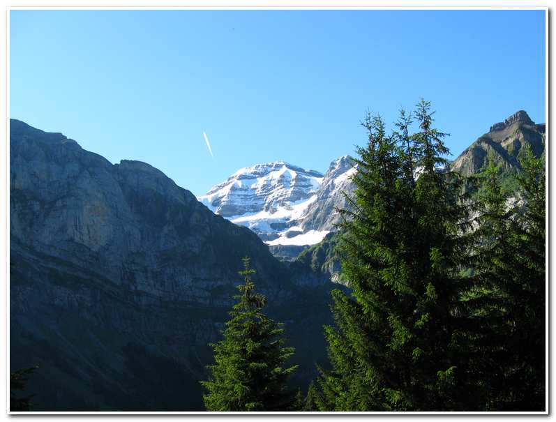
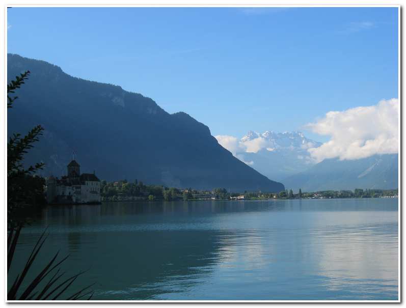
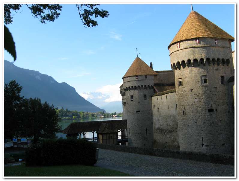
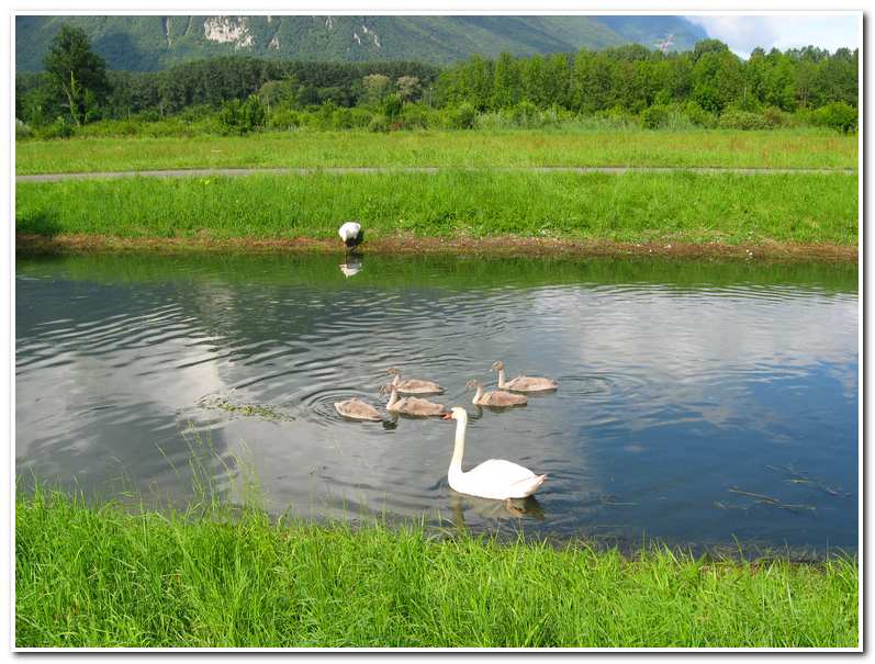
I left Montreux (8:30) and walked southeast along the lake-front promenade on a beautiful cool summer morning. In the distance I could see the Dent De Midi rising into broken clouds beyond the lake toward Chamonix. As I walked the path I passed by small fishing and pleasure boats tied up at the bulkhead and villas set back off the waterfront walkway. After about forty-five minutes I passed the famous Chateau de Chillon, a castle built on the shoreline dating from 1160. From there it was about another half an hour to the town of Villeneuve (9:45) at the east end of Lake Geneva. It was then a short hike through woodland to the town of Noville (10:20) near where the Rhone River empties into Lake Geneva. I turned southeast and followed the Grand Canal (which is actually a small canal which parallels the Rhone) up river toward Martigny. At 11:20 I branched off the canal at a road overpass and walked into the small village of Chessel (12:15)
Every once in awhile everyone has had an object lesson in just how small the world is. I had just such a lesson in Chessel. While hiking that morning I realized that it had been a while since I had trimmed my mustache and it had grown out to the point of itching my nose and lip. Ordinarily this is not a big deal, but with little else but the view on my mind, the itching had grown to become the focal point of each step I took. As luck would have it as I was walking through this tiny village I noticed a small hair salon (the only business in town) adjacent to the town square. I stopped by and through broken French (in this part of Switzerland French is the accepted language) explained to woman that owned the salon that I would like a mustache trim, if possible. She asked me to wait just outside and she would finish with her current customer and then accommodate me.
A few minutes later I was beckoned in and given a seat in the salon chair. I was just getting comfortable in the chair when the proprietress left the room for a couple of minutes and returned with a man who was apparently in his late seventies or early eighties named Ralph. Ralph, it seemed spoke perfect English and we began a pleasant conversation about Chessel and my hikes in the Alps. At some point Ralph asked where I was from and I told him, “a small island near Seattle, Washington”, not really expecting him to know anything about Seattle. Ralph’s response was “Oh, Seattle, I graduated from the University of Washington Medical School in 1952, I know Seattle well.” It turned out that he also knew a lot about Whidbey Island (my home) since he had been salmon fishing there often while he was at the U-Dub. Shortly after graduating Ralph left medical practice and became a journalist. He had moved to Switzerland thirty years ago, married the woman who owned the hair salon and had spent his time as a free lance writer. A small world indeed!
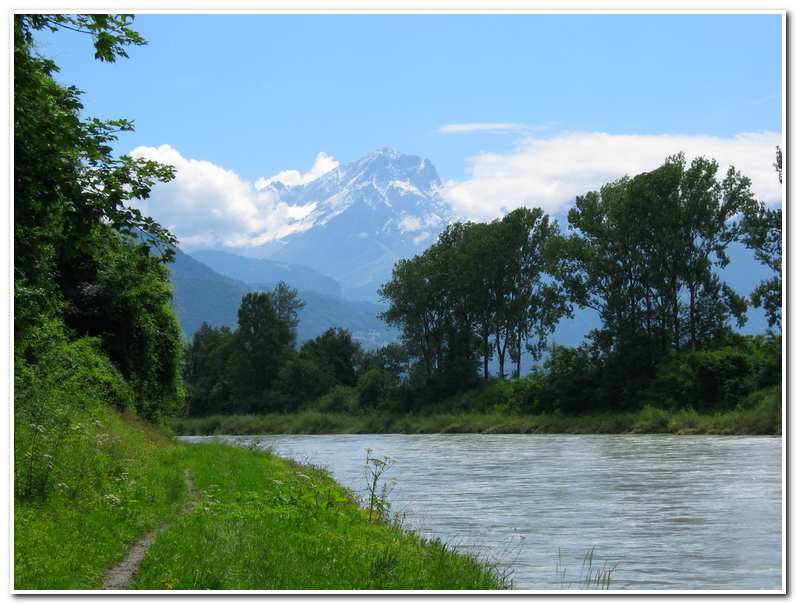
After my visit to Chessel I once again shouldered my pack and continued on my way (12:15). Ralph pointed out a small track which led to a path that followed alongside the Rhone River and featured a grand view up the river with the Grand Muveran rising in the background. The trail continued along the Rhone through farm country with small pastures and crop land as it made its way up the river eventually reaching the outskirts of the city of Monthey (2:45). Here the trail crossed the river on a pedestrian bridge and then made its way around a large chemical factory before entering the town. I walked through town and arrived at the train station at about 3:40 (ca. 1332 feet). I took a well deserved rest after the seven hours and the twenty-three miles I had walked that day.
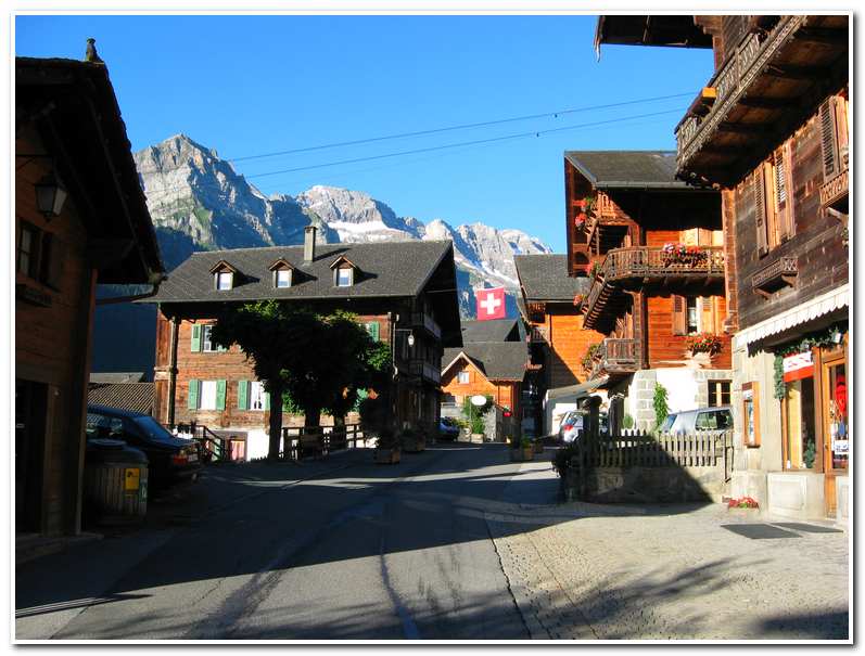
The last phase of the hike to Champery (6:15; ca. 3150 feet) was alternately up a path and winding road which made its way up-valley in two hours to this popular ski town on the western edge of the Dent du Midi. With more than thirty miles and couple of thousand feet gained that day I happily checked into the Hotel Swiss. After some rest, a good meal and a bottle of wine things were looking up and I was looking forward to the challenge that lay ahead.
- View of Lake Geneva from Montreux. The Dent de Midi in the background.
- Chateau de Chillon
- The ‘Swan Family’ on the Grand Canal near Chessel
- The Grand Muveran rising above the Rhone River valley
- ‘Main Street’, Champery
- The Dent Ruan rising above the Col leading to the Susanfe Hutte
July 13 2007 Champery to Salanfe Hutte

The day dawned bright and clear and, after a hardy Swiss breakfast of granola, yogurt, and an assortment of cheeses, I was ready to start up into the mountains. I walked out of Champery (7:45; ca. 3150 feet) and began the hike toward the Susanfe Hutte, my lunchtime goal for the day. The way out of town led slightly down toward the river and then followed a road along the river rising through a group of vacation homes until it reached Grand Paradis, a camp ground and car park for the ski resort of Champery (ca. 3460 feet). From here signs to Bonavau and Susanfe led to a gravel road which I followed for a few minutes and until a trail branched left and started a steep climb up the hillside. After a while the trail exited on a tarred road which I followed to the left for several hundred yards until the next section of the trail was reached. I then followed this path/farm track and at 9:20 reached Bonavau (ca. 5084 feet).
At Bonavau there were open alpine pastures of wild flowers at the edge of the forest and family farm/chalet where I stopped and had a coke while I rested after the 2000 foot climb up from Champery. Around 9:40 I left Bonavau and started up the high valley toward to the rocky gorge of Pas d’Encel. The trail rose gradually as I passed along the flanks of La Dent de Bonavau and after a short time it transformed into a rocky scramble of carved stone steps with cables and chains for safety. After climbing steeply up through the rock I came to a narrow pass which was the ‘gateway’ to the interior of the Dent du Midi. This was the Pas d’Encel (10:40; ca. 5900 feet). In another few minutes I reached a footbridge which crossed the stream of La Saufla. Once across the stream the trail traversed up and further into the valley. About a 15 minutes hike beyond the dam, the trail entered a beautiful U shaped alpine valley beneath the north face of Mont Ruan and the south face of the Haute Cime. The trail then wondered up this heather and rocky valley for another ten or fifteen minutes before reaching the Susanfe Hutte (11:10; ca. 6895 feet).
The Susanfe Hutte sits in a beautiful alpine valley surrounded by the mountains of the Dent du Midi and provided a good resting point before I began the trudge up the last long slope to the Col de Susanfe. I spent about an hour and a half resting here and enjoying the view while sipping a cold beer and eating a bowl of homemade mushroom soup cooked by the woman and her daughter who ran the hut.
- Wild flowers on path to Bonavau.
- Approaching Bonavau. The Pas d’Encel and Mont Ruan in the background
- The rocky approach to the Pas d’Encel
- Looking back toward Bonavau on the left and Champery in the valley
- Looking through the Pas d’Encel into the heart of the Dent du Midi.
- View toward the Tour Salliere from just below the Susanfe Hutte
After a nice rest at the hut I shouldered my pack and set out for the Col de Susanfe. I made my way up the valley, through heather and boulder meadows, gradually climbing and traversing the valley which passed the along the base of the south face of the Haute Cime (ca. 10680 feet), the highest peak of the Dent du Midi. At the head of the valley a steep series of switch backs led up the final scree slopes to the Col De Susanfe (1:30; ca. 8180 feet). This airy col connects to the south east ridge of the Haute Cime and provided a commanding view of the Lac de Salanfe in the valley eighteen hundred feet below. It also provided the first grand view of the Grand Combin and even the Matterhorn in the far distance.
After a short stay at the col I started down the east side toward the Lac de Salanfe and the Salanfe Hutte which was my goal for the day. The path was steep and scree filled, but interesting, with several gullies which had to be crossed that were assisted by fixed chains for safety. The way down was unrelenting and I quickly lost altitude and came to the valley floor about an hour after leaving the col. From here it was a pleasant walk through meadows to the lakeshore and then along the lakeshore until I reached the hut (3:00; ca. 6320 feet).
- Susanfe Hutte in the valley below the Petit Ruan on the left
- The Haute Cime and the Col de Susanfe
- The Col de Susanfe with the Lac de Salanfe below
- The southeast ridge of the Haute Cime from the Col de Susanfe
- A bivouac hut just below the Col de Susanfe.
- View across the Lac de Salanfe toward the Tour Salliere and the Col de Susanfe
July 14 2007 Salanfe Hutte to the Barrage d’Emosson

Note: The last section of the traverse from Montreux to Chamonix described in this chapter ends at Trient, where it intercepts the route from Chamonix to Zermatt described in the final chapter.
After a good sleep and yet another hearty breakfast of cheese and granola I set off from the Salanfe Hutte at 7:30 and headed out along the path that followed the south side of the lakeshore for about three quarters of a mile before reaching a trail marker which pointed the way to Lac d’Emosson. The first section of the trail led up through heather benches and alongside a small stream for about a half an hour until reaching several gentle snowfields which led up to the Col d’Emaney (9:00; ca. 8075 feet). From here a step trail led down into the Vallon d’Emaney. Once in the valley another tail junction was reached and I took the trail marked Col de Barberine which immediately started the long 1600 foot climb back up through cliff bands and, waterfalls and snowfields to the Col de Barberine (11:00; 8140 feet).
Once at the Col de Barberine the view exploded into a vista of the Lac d’Emosson in the foreground and the Mont Blanc Range behind. This col was well worth the effort needed to reach it. After enjoying the view for a while, I once again shouldered my pack and set off down the step south side of the col on a trail that led down to the lake. I descended steadily for about an hour eventually reaching a track which ran along the lakeshore (12:00; ca. 6340 feet). Just before reaching the east end of the lake and the Barrage (dam) d’Emosson the trail led through a long tunnel before emerging at a restaurant and tourist stop near the dam. From here a road and a trail led down into the valley about 2600 feet below and to the main road connecting Chamonix and Martigny.
Before starting down the trail to the valley and beyond to Trient I enjoyed a tall beer and a plate of Wiener schnitzel. I gave my poor old legs a much needed rest. At about 1:30 I started down the trail to the valley floor. From there it was only another hour of valley hiking around to the small village of Trient.
- On the trail up to the Col d’Emaney
- The Col d’Emaney looking back toward the Lac de Salanfe
- Looking across the Vallon d’Emaney toward the Col de Barberine
- View from the Col de Barberine toward Mont Blanc in the distance
- View over the top of the Barrage d’Emosson toward the Mont Blanc range
- View from the Barrage d’Emosson toward Mont Blanc


