Black Horse Racing Header

“If you’re not moving, you’re standing  still.”


Steve Trafton

Tour de Matterhorn

Tour de Matterhorn
Arolla to Zermatt
Circa: 145KM – 90 Miles

July 2006

image1

.


Phase 1: Arolla to St. Niklaus July 2006

Stage 1:  Arolla – Les Hauderes – La Sage – Villa

image2
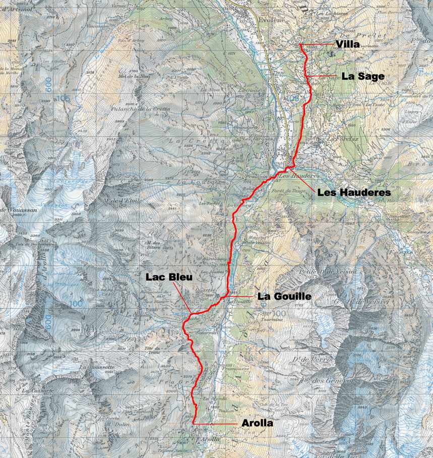
NOTE: The route from Arolla to Zermatt was done in several separate sections. Some were done west to east and some east to west. Each section is shown in west to east order with the correct dates of the sections indicated.


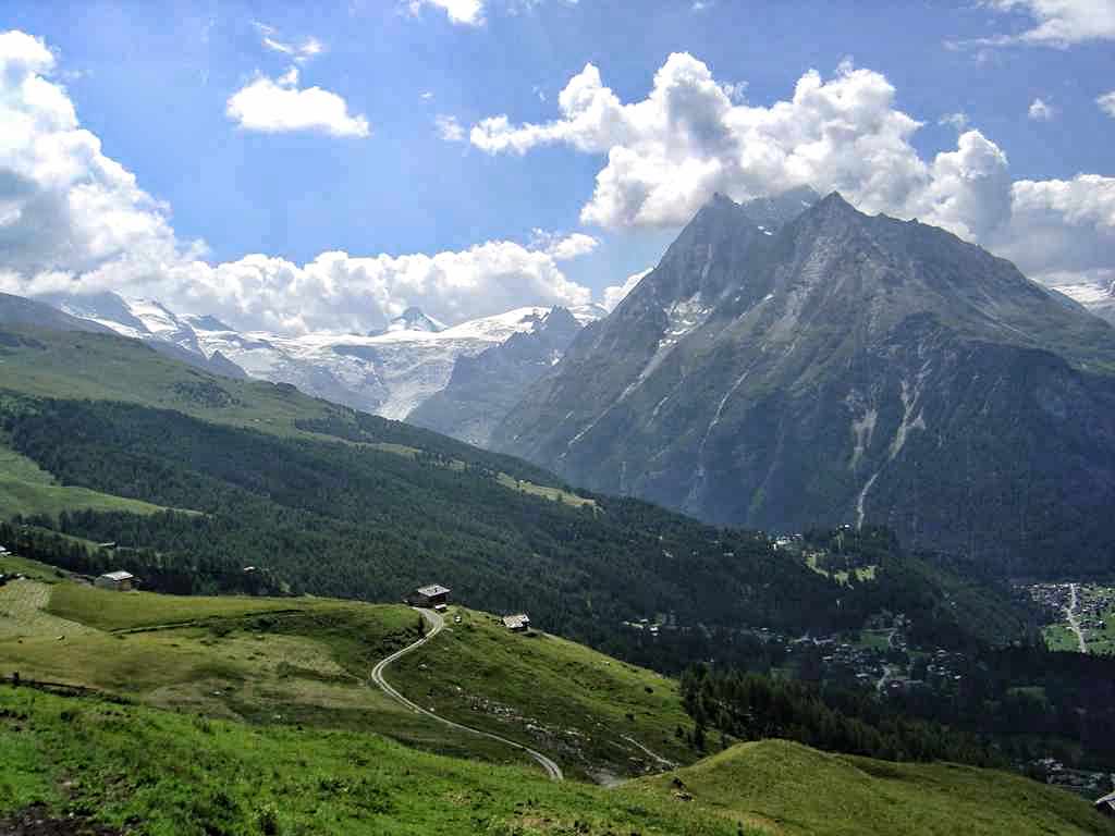
7/22 
Left the main village square of Arolla about 8:00a and walked down the side road towards the Hotel de Glacier. Shortly before coming to the hotel a footpath broke to the left which climbed and then bore right along the hillside before reaching the Centre Alpin. I continued along on the wooded hillside gradually ascending and traversing northward before crossing a stream below an alp hamlet. From here the trail continued as a traverse of the now open hillside across several more streams and then onto an open grassy bluff overlooking the Lac Bleu (2089m – 6855ft) (9:15a). From the Lac the trail descended from the eastern outflow of the Lac along a path to the alp hamlet of Louche where cheese and milk is produced. From Louche the trail once again dropped into the forest and continued to La Gouille (1844m – 6050ft) (9:45a), on the road between Arolla and Les Hauderes. After walking down the road a short distance the trail went right and descended below the road, traversing the hillside above the Arolla River for a little more than an hour before reaching the town of Les Hauderes (1451m – 4760ft) (11:00a). From Les Hauderes I followed the signs along alternating road and pathway to La Sage (1375m – 4510ft) and then on to Villa (1730m – 5676ft) (12:45p). Once at Villa I took the trail down to Evolene (1375m – 4510ft) where I caught the bus to Scion, then the train up the Rhone valley to Sierre-Siders and then the bus to Zinal where I spent the night before starting the hike back to Villa to complete the Arolla to Zinal route.
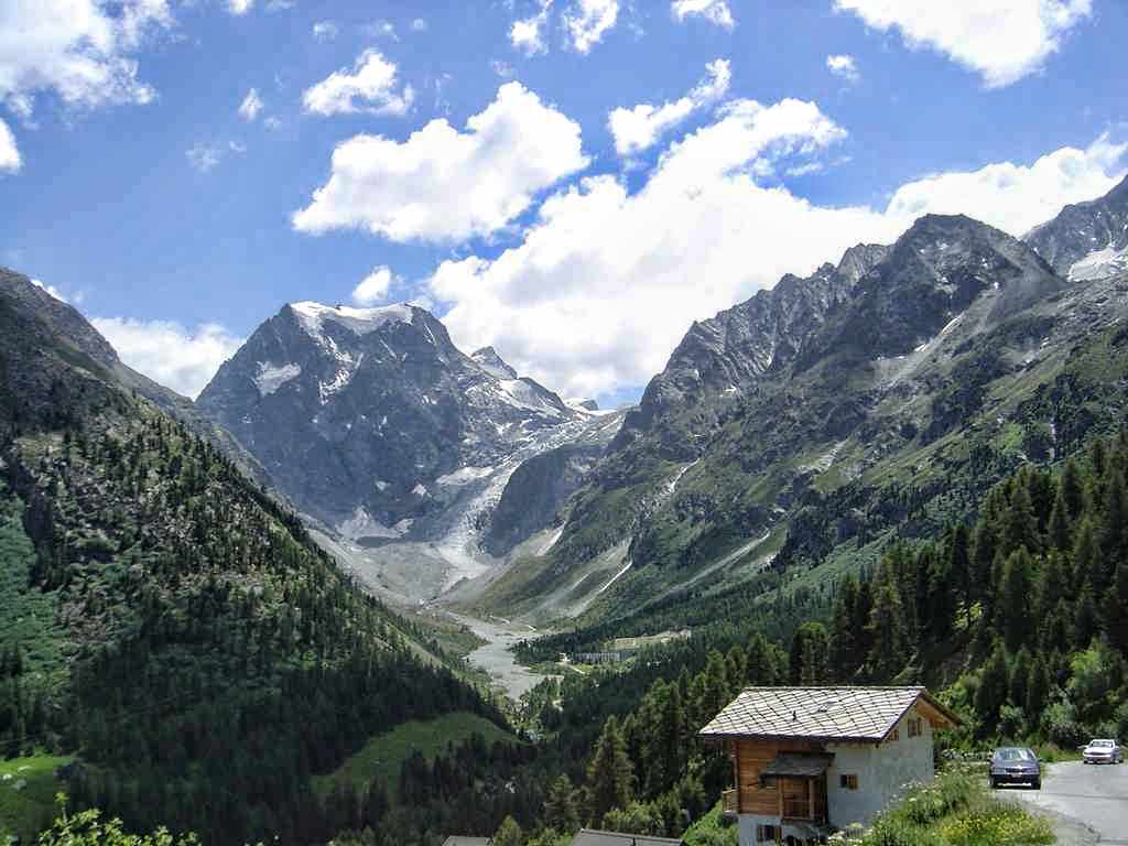

Stage 2: Zinal – Col de Sorebois – Moiry Dam – Col de Torrent – Villa

image5
7/23  
I arose to a nice sunny day and left the hotel in Zinal (1673m – 5490ft) (7:40a) and headed for the Sorebois tram station at the north end of town. I was just in time to catch the first tram to Sorebois at 8:00. After a ten minute ride I arrived at the upper tram station (2436m – 8000ft) and set off for the Col de Sorebois about a mile away along heather hillsides and pastures. I arrived at the col (2835m – 9301ft) (9:00a) and then walked up the Corne de Sorebois (2896m – 9501ft). To the west was the Lac de Moiry, and to the east was a magnificent view of the Weisshorn 4505m – 14,780ft). After a nice rest I continued on over the pass and began the descent into the Val de Moiry. The trail was steep in many places but overall not too bad and the views made up for the 2100 feet of elevation loss. I arrived at the Barrage (dam) de Moiry (2556m – 7400ft) (11:00a) just in time for a few beers and some lunch.

I left the barrage at about noon, walked across the dam and then followed a gravel road up several switch backs, past a farm and then across pastureland, gently rising further until I came to the shores of Lac des Autannes (2682m – 8800ft) (12:50p). The trail then continued on around the north side of the lake and rose in a series of long switch backs up boulder and scree slopes before emerging at the Col de Torrent (2919m – 9577ft) (1:45p). On the path between the lake and the col I ran across an inspiring sight. A French woman, well into her seventies or early eighties, along with her two golden retrievers was coming along the path from the col. We exchanged “bon jours” and continued on our separate ways but the image of the elderly woman so contently hiking along with her two dogs would stick with me for a long time.

After resting at the col for about a half an hour I started off once again. The west side of the col proved to be a long descent, steep in some places and gently downhill in others. It took about two hours to make the descent all the way to Villa (1730m – 5676ft) (3:45p). From there I once again walked further down into the valley to the village of Evolene (1375m – 4510ft), nearly 5100ft below the Col de Torrent! Ready for a rest and a few more beers I checked into a hotel in Evolene and spent a much earned rest before continuing my travels.

.Stage 3: Zinal – Pas de Forcletta – Gruben-Meiden

image19
7/16 
My brother Dwight and his son Byron and left our hotel in Zinal at 6:30a and walked a few feet down the main road before turning left and up a side street past the church. We continued up the hillside out of town to the apartment complex signed Formula 1, then crossed the road and walked up a narrow road/driveway with a signpost to Hotel Weisshorn. Above the buildings a way marked track headed to the right and rose among stands of larch and soon crossed an avalanche defense system. Once across this the path rose steeply through the forest in a series of steep switch backs which soon rose up out of the valley. After about 45 minutes from the hotel the route eased a bit and began a gentle but consistent traverse. About a half an hour further on we came out of the trees and onto a beautiful open shelf of hillside (2172m – 7125ft). The trail continued its gentle but persistent ascent north along the hillside above the Zinal valley and after about two hours we arrived at Barneuza Alpage farm amid the high pastureland (2210m – 7250ft).

The route continued on ahead and in another half an hour we reached Alpe Nava (2339m – 7674ft). Here the trail split, with the left hand path leading on to the Hotel Weisshorn, another hour and twenty minutes further north. The path we wanted, to Pas de Forcletta, followed a steep trail beside a stream into an upper basin before veering left and up to another farm, Tshalet (2522m – 8275ft). The route then followed a trail, up rocky slopes in long switch backs across heather and scree to reach the Pas de Forcletta (2874m – 9427ft) (9:55a). From the pass the trail slanted down to the left over rolling pastures and came to the farm buildings of Chalte Berg (2487m – 8160ft) (11:20a). We followed the track between the alp buildings and then followed a trail which paralleled the road, later dropping below it to the alp huts at Masstafel (2234m – 7330ft). From here the way descended down through the forest finally coming to the valley bed about a mile up valley from Gruben-Meiden (1823m – 5980ft) (12:45p). The weather had turned hot by the time we arrived at Gruben Meiden and so double the amount of cold beer was ordered to quench the thrust of the weary travelers.


Stage 4: Gruben-Meiden – Augstbordpass – St. Niklaus

image28
7/17 
The trail to the Augstbordpass started on the south side of the Hotel Schwarzhorn in Gruben-Meiden, where we spent the night. It led uphill over a grassy pasture and then through a wooded section of larch and pine. After about 35 minutes we came to a trail junction at Gruobualp (2150m – 7055ft) (7:50a). From here the path passed to the right side of the huts and headed uphill to the left of a stream in the hanging valley of Gruobtalli. The trail continued to rise to a lumpy inner region of the valley with scree slopes lining the southern wall of peaks, and grassy hummocks elsewhere littered with grey-green lichened rocks. Shortly before 8:30a we hiked up over a rocky step, then descended slightly to go around a small pond before rising again, this time at a steady incline on the final stretch to the Augstbordpass (2894m – 9494ft) (9:00a).

We took our packs off, had a victory cigar and rested, enjoying the view out over the Inners Talli valley, east of the pass, and the Fletschhorn (3918m – 12,854ft). A clear path led down from the pass in switch backs to a rocky bowl on the eastern side of the cirque that holds the Inners Talli. After the first steep section the path eased its descent and about twenty minutes from the pass we passed through a narrow rocky cleft and emerged into a rock and grass alp. In a few more minutes we came to a trail junction and took the Jungen/St. Niklaus option that sloped down and then hugged the right hand side of the valley, crossing over the Embdbach stream.

The route then started a gently rising traverse of the southern flank of the valley heading east across a slope of boulders and rocks. We continued the traverse until we reached the shoulder of a small mountain (2487m – 8160ft) where we could look down into the deep cut of the Mattertal. Continuing on round the shoulder the path narrowed and rose steadily, climbing several rocky steps and turned a ridge at Troura (2656m – 8714ft) (11:05a). Here we were treated to one of the best views of the entire stage of the trip. Across the Mattertal soared the Nadelhorn, Lenzspitze, and the Dom, with the Reid glacier pouring into a narrow gorge above the village of Grachen. To the right, at the head of the Mattertal, Liskamm, Castor and Pollux and the long white block of the Breithorn, with the small pyramid of the Kleine Matterhorn completed the panorama. After just a few more paces the Weisshorn exploded into view.

In a short distance the path became a paved track which wound down, in wide loops until Untere Lager (2254m – 7395ft), a prominent trail junction was reached. We took the trail marked to Jungen Rundweg which wound down through boulder strewn forest eventually reaching Jungen (1954m – 6410ft), a pleasant alp hamlet perched on the hillside high above the Mattertal and the town of St. Niklaus. Jungen provided, not only a chance to rehydrate with the local beer, but also to enjoy the great views down the Mattertal while sitting on the patio of the little family run restaurant trailside near the church. The last bit of trail led below the restaurant and zigzagged into the forest below the village. After about a half an hour we came to a junction where we continued straight ahead and crossed a rocky cleft on a footbridge over a wild stream. The trail continued down through forest and pastureland and eventually emerged near the St. Nicklaus train station (1226m – 3695ft), some 5800 feet below the Augstbordpass.

Phase 2: Zermatt to St. Niklaus

Stage 5: Zermatt to Europahutte July 2001

image35
Al Errington, my son John and I left our hotel in Zermatt (1600m – 5249ft) and caught the first funicular train up the east side of the Mattertal to the top station at Zunnegga (2288m – 7507ft). Once there we followed the signs down the road to Tuftern (2215m – 7267ft) and then continued on, taking the trail marked Europaweg. This trail led along the hillside and around into the charming Taschalp Valley and the hamlet of Ottovan 2187m – 7175ft) where we could look northeast up the valley to the Taschhorn (4490m – 14,731ft). We followed the road out of Ottovan for a short distance and then turned right onto the continuation of the Europaweg. The trail followed a good route amongst Arolla pines and larch.

Before long we reached a sign warning of rock fall where the path was protected by a concrete platform, then two tunnels. Afterwards the path climbed up past the first possible descent route to Randa, with good views of the famous Randa landslide. In April and May 1991 there were several landslides on the westerly hillside above Randa. The biggest one blocked the railway line, the road and the river, and the military were brought in to build a temporary floating road to evacuate people stranded in the upper Mattertal. Miraculously no one was hurt.

From the Randa trail junction the route made an improbable hillside traverse, protected by rope railings, and then a bridge across a gorge to lead to another tunnel, this time cut into the rock. After a short climb the trail came to a picnic table next to another trail down to Randa. From here it was a short hike to Europahutte (2200m – 7218ft) (11.1miles from Zermatt). We checked in with the hut warden and then explored the area around the hut and enjoyed the view of the Weisshorn (4505m – 14,780ft), the second highest peak entirely in Switzerland.


Stage 6: Europahutte to St. Niklaus

image41
We left the Europahutte early the next morning and continued following the Europaweg north toward Grachen. We soon came to several rocky sections which were subject to rock fall. Here we were again protected by a tunnel. Next we traversed a gorge and soon after came to a steep path which headed off left down to Breitmatten and Herbriggen. After another 100m of ascent we reached the highpoint of the trail at 2663m (8737ft). From here it would be downhill all the way, but it didn’t really feel that way! Far below us was the Mattertal and on the opposite hillside we could see the hamlet of Jungen, high above St. Niklaus. Soon we came to a statue of St. Bernard (1523m – 4997ft), the 11th century patron saint of alpinists, who established two hospices on high passes in the Alps to protect travellers and pilgrims. Grachen could now be seen on the other side of the valley ahead of us. From the statue we descended steeply down and into the forest. After a while we came to the village of Gasenried 1659m – 5443ft), and  then about a mile further on, Grachen (1619m – 5312ft). Here we spent the night and enjoyed a much needed rest. It was but a short bus ride down the mountain to St. Niklaus.


Note: This completed the route from Arolla to Zermatt, the northern portion of the route around the Matterhorn. Katherine and I would undertake the southern arc going from Arolla, south into Italy and then back to Zermatt in September of 2009 completing the entire Tour de Matterhorn.


Phase 3: Arolla to Zermatt

Stage 7:  Arolla – Col Collon – Rifugio Prarayer Sepember 2009

image45Stage 7a: Arolla to Col Collon


9/7  
Katherine and I flew to Geneva and then took the train to Sion where we caught a bus to Arolla. We carried our gear up the road from the bus stop to the Hotel du Glacier where we got a room and sorted our equipment for the hike to the Prarayer the next day. It was a

9/8   We got up about 7:00a and had breakfast. We had made arrangements the night before for a ride to the end of the road and the trailhead leading up the valley to the Haute glacier Arolla and our driver was ready to go at 7:45a. Once at the trailhead we followed the path heading up the left (east) side of the valley. Ahead we could see the steep slopes of the North Face of Mont Collon. After a short time we reached a trail junction, the upper trail led to the Plans de Bertol; we took the lower trail which stayed low and skirted around under the rocky shoulder to the Bas Glacier d’ Arolla and, after a short distance, past a dam and water reservoir, where a ladder was set into the rock to ascend above the dam. Once up the ladder we traversed across a rock face added by cables into the upper valley.

From here we took a path continuing up the valley to the snout of the Haut Glacier d’ Arolla. Once at the glacier we continued up the lateral moraine and boulder fields. We followed the moraine for quite a way until we could see a way across the glacier marked with blue wooden tripods. As we crossed the glacier we aimed for the base of a large rock outcropping (the Veirge). We continued following the glacier steeply up past the right side of the outcrop. As we got higher the angle decreased and soon we reached the Col Collon (3087m – 10,128ft) (11:05a) and once there we could see the snowy west slopes of Mont Brule’ and in the distance the Dent d’Herens. The Col Collon has been a much used pass for centuries. From around 1220 AD a band of thief’s from Evolene regularly raided the Valpelline village of Bioaz, which resulted in reciprocal raiding from the Valpelline people. In 1233 a peace treaty was signed between the two valleys, which was reiterated 100 years later with a pact to provide mutual help between the towns. From then on there has been an agreement that allows the Evolene farmers to graze their cattle over in the Valpelline Valley. Good relations continued with much trade between the valleys, but the advance of the glaciers in the 18th century changed all this by effectively cutting off the trade route.


Stage 7b: Col Collon to Prarayer

image57
We stayed at the Col for about an hour while I enjoyed a cigar and we took in the view. At 12:05p we left the col and followed the trail left across and slightly up to reach a sign which stated 45 minutes to the Rifugio Collon-Nacamuli (2818m – 9245ft). From this point the way wove down and back to the right and was marked by yellow paint marks on the rocks. Eventually we came to the path leading up to the hut which we followed. Unfortunately the hut was closed for the season and so our hope of refreshments would have to be put off until we reached Prarayer. Once we left the hut we took a short steep trail down below the hut and intercepted the main trail leading down past several tarns and stream crossings before the trail came to a steep descent over rock aided by ladders and sharp switch backs in the trail. Once down this steep section we reached a gentle path which wondered through the Comba d’Oren and past the alp farms at La Garda (2211m – 7254ft). From La Garda we followed the path left and down through pastureland east to Prarayer (2005m – 6578ft) (2:55p).

Stage 8: Prarayer – Rifugio Peruccah-Vuillermoz

image67
9/9  
We left the Rifugio at Prarayer at 8:10a in light low valley fog. We walked a short distance up the valley beyond Prarayer and then down to cross a bridge over the river leading into the lake. Once across we entered the forest and after a short distance the path reached a junction where trail number 12 goes left and number 13 goes right. We took trail number 12 which was also labeled number 3 in a triangle denoting that it is an alta via (high route) number 3. The trail took well- graded switchbacks up through the forest to the tree line where a newly constructed alpage was passed, and continued along an old track that headed up into the Comba di Valcournera. The Colle di Valcournera was soon visible high up on the left and a very obvious boulder with a painted sign marked the spot where we left the track and started up the steep slopes toward the Colle.

The path was steep, but well graded and we quickly gained altitude, especially on the section which was equipped with an easy via ferrata of rungs and chains. Soon we emerged from the valley fog and were treated to spectacular views back toward the lake and the Comba d’Oren that we descended the day before. After a long climb we reached a flat area where we took a well-deserved rest. From here we crossed a large boulder field which guarded the final steep slope up to the colle. As we climbed the last slope we stayed to the center right and finally topped out at the Colle di Valcournera (3066m – 10,059ft) (11:40a). The colle was marked with a wooden cross and here we sat and had a short snack. The Rifugio Perruccah was just below nestled next to the deep blue waters of the Lago del Dragone.

About noon we started our descent to the rifugio down the very steep east side of the colle. Several snowfields had to be crossed, but once past those the trail eased up and we were able to walk down a good track, bordered by large stones to reach the Rifugio Perrucca-Vuillermoz (2910m – 9547ft) (1:10p).

Stage 9: Rifugio Peruccah-Vuillermoz – Breuil-Cervina

image82
9/10  
We left the Rifugio Peruccah-Vuillermoz at 8:10a and crossed over the dam below the rifugio, then traversed the rocks below with the help of some chains, before traversing a short distance to the little red Bivouac Manenti (2806m – 9206ft). The trail then passed a cave in the cliffs, before continuing down past a beautiful cascading waterfall to a flat viewpoint by a big cairn. Ahead lay the artificial Lago de Cignana. We followed the trail which soon became a track down to the Alpe di Cignana (2298m – 7539ft). From there we climbed through the pasture and along a farm track to the Finestra di Cignana (2442m – 8009ft) (9:40a). A short distance past the Finestra we rounded a corner and were treated to our first view of the Matterhorn (4478m – 14,692ft). From here we followed the path on a long gradually descending traverse northeast.

All too soon the trail began a series of switchbacks down through meadows and larch forests to a junction at Monteau. We took the trail which lead down through pastures past a water source to a strange open area of earthworks, where there is a water fountain.  From there we walked back into the woods and descended to a bridge and the main road at Perreres (1837m – 6026ft) (11:30a). Here we stopped for a beer before catching the bus into Breuil-Cervina (2006m – 6581ft) (12:30p). We spent the nght in a fine little hotel and rested for our final leg of the Tour de Matterhorn the following day.

The Matterhorn from Breuil-Cervina

Stage 10: Breuil-Cervina – Theodulpass – Zermatt

image94
9/11  
We left Breuil-Cervina at 8:10a taking path 15 signed just before the lift to Plan Maison on the left. The path wound up through meadows past chalets, first to the left of the lift, then traversing underneath, and then continuing to climb more or less following the line of the cables. After one hour we reached the Albergo Plan Maison (2457m – 8061ft). The views of the Matterhorn were excellent from here, and all the way onwards, but there are a number of other lesser-known summits to see as well, the Dent d’Herens, the Punta Margherita, and a whole series of rocky peaks running south from here. Ahead and east are the Plateau Rosa and Test Grigio, and further to the right the Ventina Glacier, which tumbles down from the Gobba di Rollin. From Plan Maison we continued on path number 15 which was signed to the Theodulpass. This path took off straight towards the pass and was generally signed by yellow arrows all the way. To begin with route finding presented no problem and we climbed fairly quickly up past a track going off left to a café. At the next junction it was gentler to go left, but we followed the jeep track which was steep but shorter. Continuing on the track led to two lift stations, named for their respective altitudes; Plan Maison 2866 and Plan Maison 2876.

The path then continued on up to the lift station at Bontadini (3044m – 9987ft). From here the yellow waymarks are rather sparce and difficult to follow. Basically the path set off from the left side of the upper lift, signed 15 and TMR, then went over to the right of the lift. The shiny metal Theodulhutte could be seen. From here there are a number of paths all of which lead up eventually arriving at the hutte (3317m – 10,883ft). We descended from the hutte down a rocky path to the Theodulpass (3301m – 10,830ft) (11:20a). From the pass it was a short, but steep descent down to the Oberer Theodule Glacier where we followed the ski run down. To our left was the Matterhorn, while up ahead was Mattertal Valley flanked by the Dom and the Taschhorn to the right (east) and the Weisshorn, Obergabelhorn and Zinal Rothorn to the west.

When we had descended to about 3100m (10,171ft)  we started across the glacier to its right margin and the rocky ridge that gives access to Gandegghutte (3029m – 9938ft). Once we reached the lateral moraine we climbed up to near the top of the ridge and picked up the trail to the Gandegghutte (12:20p). It was a beautiful sunny day and we relaxed and enjoyed a big lunch and rested before hiking on down to the Trocknersteg Station (2939m – 9642ft). Here we caught the tram down and Furi and finally to Zermatt. Once down we treated ourselves to several nights at the Hotel Zermatterhof and a celebratory climb of the Breithorn (4164m – 13,661ft).