Black Horse Racing Header

“If you’re not moving, you’re standing  still.”


Steve Trafton

Walkers High Route: Chamonix to Zermatt

The Walkers High Route
Chamonix to Zermatt
2006

The Matterhorn from near the Gornergrat

The Matterhorn from near the Gornergrat


The Walkers High Route: Chamonix to Zermatt leads from the base of Mont Blanc to the Swiss border at the Col de Balme, and from there down to Trient. Then a long steep climb leads to the Fenetre d’Arpette before the trail descends to the village of Champex. From there the route leads down to the junction of Val d’Entremont and Val de Bagnes, then curves around the foot of the mountains to Le Chable. From Le Chable the route climbs past Verbier and around Mont Fort to the Cabane du Mont Fort, and then continues high above the valley heading south east before crossing three cols in order to pass around Rosablanche. From the last of these cols the trail descends to the Cabane de Prafleuri and then over Col des Roux and along the shores of Lac des Dix before ascending to the Cabane des Dix literally at the foot of the north face of Mont Blanc de Cheilon. After a pleasant lunch on the veranda at the Cabane des Dix the trail markers lead across the Glacier de Cheilon to a series of vertical ladders ascending to the Pas de Chevres. After a brief rest at the Pas a gentle alpine trail leads down to the village of Arolla. The trail then follows the valley down to Les Hauderes and up to the small village of La Sage set high on the hillside above the Val d’Herens. The route then continues to Villa before ascending to the Col de Torrent. From this airy col the trail quickly descends down into the Val de Moiry before climbing once again to the Col de Sorbois and the Val de Zinal. After passing through the ski village of Zinal and route climbs steeply yet again to the Forcletta the switch backs down to Gruben-Meiden in the Turtmanntal. From Gruben-Meiden a final climb leads to a crossing point at the Augstbordpass before the trail make one last plunge down into the Mattertal at St. Niklaus. From here it is pleasant hike up the Mattertal, past Tasch and on to Zermatt and a well deserved rest after having completed 110 miles of strenuous hiking on one of the truly classic alpine traverses.

July 7 2006 Side Trip to Lac Blanc

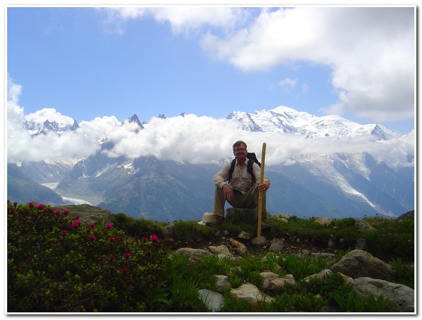
After having finished the Alpine Pass Route, from Sargans to Montreux in July 3rd, I spent several days in Montreux resting and attending the Jazz Festival before heading to Chamonix on the 6th where I would laze around and hike for a few days before meeting my brother Dwight and his son Byron on the 9th prior to starting our undertaking of the Haute Route to Zermatt. While waiting in Chamonix I went on a spectacular hike to Lac Blanc, along the so-called Grand Balcon.

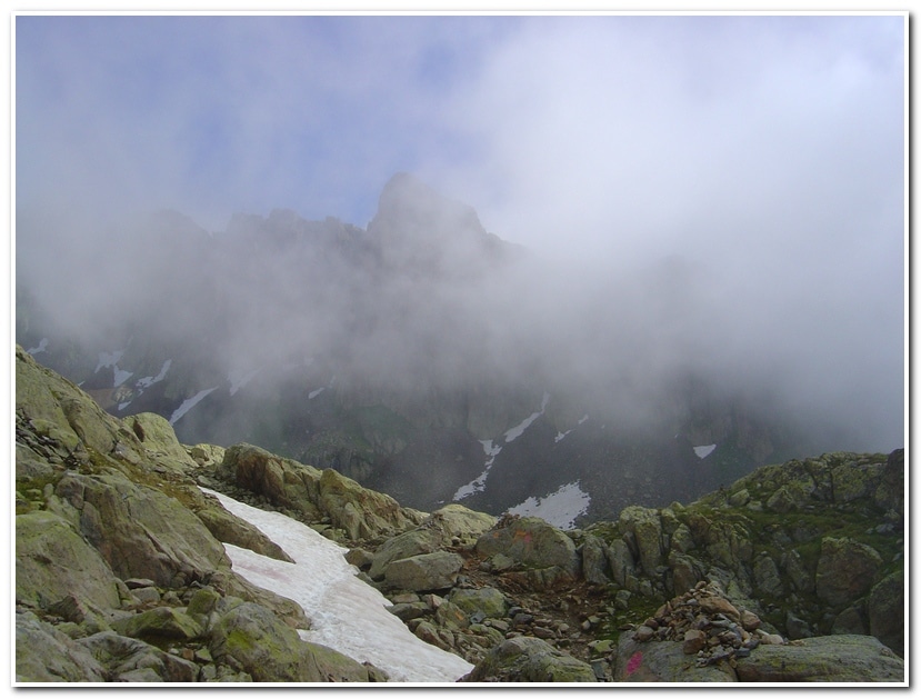
I left Chamonix just after breakfast and walked north, up the valley to Les Praz de Chamonix where I caught the Flegere-Index cable car and rode to Index la Gliere. It was foggy at the top but I was able to follow the path through scree rubble at the upper station and do a gradual descending traverse around a rocky rib and into a high col de sac with several little tarns. From here the trail led around another rocky ridge and ascended slightly through a boulder field before coming to Lac Blanc.

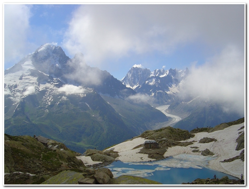
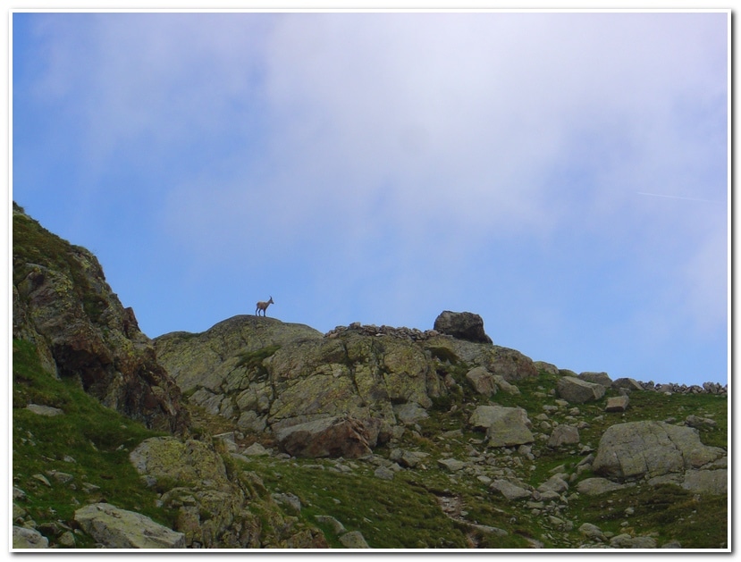
The views from the lake were spectacular as the clouds parted and revealed the Aiguille Verte, the Chamonix Aiguilles and Mont Blanc. I sat in the Azalea filled alp surrounding the lake, watched an Ibex scamper along a rocky ridge nearby and enjoyed a nice snack and a fine cigar that I had stashed in my pack.

Life was good at Lac Blanc.


The Haute Route

July 10 2006 Chamonix to Argentiere

image011

Our little party left Chamonix via the Brevent tram which we took to the intermediate station at Planpraz. From here a short walk up a small road led to the Chalet de Planpraz where a sign pointed out the tail to Flegere. The trail generally followed the 6500 foot contour northeast along the west side of the Chamonix valley, below the Aiguilles de Rouges. The trail went through alpine meadows and light forest with great views east to Mont Blanc and down to Chamonix in the valley below. After about an hour we came to the intermediate station of the Flegere-Index tram and took a rest stop before continuing on north, through open alpine meadows, to a trail junction near the Chalet des Cheserys, below Lac Blanc. Here we began our descent to the village of Argentiere 2450 feet below. We reached Argentiere (4100 feet) at 12:40 and stopped for a much deserved beer and hamburger lunch before continuing on toward Col de la Forclaz.


July 10 2006 Argentiere to Col de la Forclaz

image017

After a lunch break at Argentiere we literally hit the road and began the two mile walk up the road to Le Tour (ca, 4765 feet), a ski area just below the Col de Balme. After a short ride up the chair lift we traversed over to the Col de Blame (2:40; ca. 7230 feet) and enjoyed the view across to the Aiguilles Rouges and the Dent du Midi rising to the west. Superb views were also to be had to the south toward Mont Blanc and the Chamonix Valley. The Col de Balme also marks the Swiss border with France and on the other side of the col we could see down to the Trient Valley.

From the Col de Balme we started down through alpine pastures on trails and farm tracks until at last the route steepened into a long series of switch backs which continued down through a forest until coming out into pastures on the valley floor about a mile outside Trient (3:45; ca. 4195 feet). We followed the trail system to the edge of town and then turned and began climbing the opposite side of the valley steeply upward until we at last topped out at the Col de la Forclaz (4:30; ca. 5005 feet). We checked into the Hotel Du Col De La Forclaz and spent the next couple of hours drinking beer and smoking bad cigars on the patio while reminiscing about the long day we had just finished and the even harder day that we expected to come.


July 11 2006 Col De La Forclaz to Champex

image023

After a leisurely breakfast (7:30) we set out down the level track which traversed along the mountainside, above the Trient River, up the valley toward the Trient Glacier. The first two or three miles were nearly level and followed an aqueduct, or bisse, that ran from the upper reaches of the Trient River and the Col de la Forclaz. After about three miles (8:30), at a remote alpine cabin, the trail turned and began a sharp rise up toward the Fenetre d’Arpette. The route climbed up heather benches and through boulder fields and little patches of trees before reaching the base of the final slopes up to the pass. Here we began climbing a long series of difficult, steep switch backs which ascended sharply until reaching the narrow Fenetre d’Arpette (10:20; ca. 8740 feet). We rested at the col for a while, had a good cigar and psyched ourselves up for the brutal down climb to Champex on the other side of the col.

At first the descent dropped into a rough, stony bowl at the head of the Val d’Arpette. The first hundred yards or so were the steepest, with a lot of loose rock and scree. After this we crossed a large boulder field before the path finally eased and began following the stream down the valley. After about an hour and a half, the path reached Arpette and the restaurant Relais d’Arpette (12:45; ca. 5335 feet). Here our bone weary little troop rested and partook of several ‘grosse biers’ and Wiener schnitzel. About an hour later we set off once again down the road to a footpath which descended among trees, following a fast flowing bisse which gradually made its way through the woods and took us into the village of Champex (2:45; ca. 4810 feet). From Champex we opted to take a short bus and train ride to Le Chable and then up the hillside the Verbier (5:40; ca. 4885 feet). Verbier is a major ski resort with good accommodations and excellent restaurants. This would be our starting point for the next stage to Cabane du Mont Fort.


July 12 2006 Verbier to Cabane du Mont Fort

image039

After the last two days of hard hiking we were ready for a day of leisure. The route from Verbier to Cabane du Mont Fort promised to be both scenic as well as undemanding. The main achievement would be to leave the ski resort atmosphere of Verbier behind and once again enter the high Alps. We started (9:00) by taking the tram from Verbier to Les Ruinettes. From here, a track led on a gentle traverse on the 7200 foot contour around the shoulder of Mont Gele (ca. 9915 feet) into a high alpine pasture. Cabane du Mont Fort (ca. 8060 feet) sat atop a rocky mound tucked in beneath the ridge that ran from Mont Gele and Mont Fort (ca. 10915 feet). By 10:15 we were sitting on the patio of the cabin enjoying the view out toward the Grand Combin group and settling back for a day of reading and relaxation, and fine cigars!


July 13 2006 Cabane du Mont Fort to Cabane de Prafleuri

image045

We left Mont Fort at 6:30 in partly cloudy/foggy condition and descended the mound on which the hut sits to a signed junction marked Tour du Val de Bagnes et Combin. From here we followed a series of tracks leading to a trail which made a gradual traversing ascent of the hillside across from the hut. After rounding a prominent corner we lost sight of the hut and continued on the path, southeast toward the Col Termin. After about an hour we reached a scree and boulder section of the trail where we saw several Ibex making their way along the rocky ridge ahead. The trail then gained the ridge and continued around the mountainside on a narrow but easy trail. By 8:00 we had reached the Col Termin (ca. 8685 feet), an obvious saddle in a shoulder of the Bec Termiin which rises to the north. We rested for about a half hour and enjoyed the spectacular view emerging through the now clearing skies.

After descending the east side of the Col Termin and taking in the view of the Lac de Louvie we came to a junction. Here we veered sharply left and took the path marked Col de Louvie and Prafleuri. This path led through a rugged rocky cirque where we again spotted Ibex in the rocks above the trail.

About an hour from the Col Termin we came to another junction where the trail up Mont Fort broke off to the left. We continued straight ahead, crossed another rough boulder field then skirted the left side of a narrow boulder- filled valley and climbed to gain the Col de Louvie (9:40; ca. 9580). Here we were greeted by the barren landscape of the “Grand Desert”, a wilderness of scree, moraine and the dying glacier on the north west side of Rosablanche (10940 feet).

Descending from the col the trail stayed left and we lost altitude quickly as we dropped down into the Grand Desert. We followed the way marks and occasional cairns that led down to the outflow steam at the northern end of a glacial tarn (ca. 9050 feet) below the snout of the Grand Desert Glacier. Once over the stream we made our way north east up across a vast stony wasteland to a line of cairns and way marks which took us past a series of beautiful little tarns which made for a nice rest spot after the trudge across the Grand Desert.

After the tarns we crossed granite slabs, ascending and descending some short cliffs before making one last steep ascend up through rough granite blocks and scattered rocks to the Col de Prafleuri (11:25; ca. 9725 feet). As hard as the hike to the col was we were now nearing our destination. The descent from the col was via a steep and winding path down to a level section beneath the Glacier de Prafleuri. After this the way dropped steeply again into a valley below. About a half hour from the col we reached the Cabane de Prafleuri (12:00; ca. 8605 feet). Once the boots came off and sweaty clothes were replaced with dry ones the beer flowed and all was right with the world.


July 14 2006 Cabane Prafleuri to Arolla

image071

After a good night’s sleep we got up early, had breakfast and hit the trail at 6:30. From the Cabane de Prafleuri took the trail to the obvious pass just to the south of the hut. The trail led up a slope of boulders and rocks which led quickly to the Col des Roux (ca. 9200 feet). The route crossed over the Col and continued on, descending through boulders and scree at first, then grass and heather-slopes down to a farm chalet at La Barma (7:30; ca. 8060 feet), just above the Lac des Dix.

From La Barma the trail followed the track around the lake to its south end where a signpost marked the trail to Cabane Dix leading sharply up and to the right. The trail then ascended fairly quickly passing through a series of rock bands and heather-slopes until it reached an upper valley moraine next to the Glacier de Cheilon. Towards the end of the moraine the path forks and we took the right hand option which led over rising grassy slopes and onto scree by which we gained the northwest shoulder of the Tete Noire. The Tete Noire hid both Mont Blanc de Cheilon and the Cabane des Dix until the last moment. As the trail rose toward the saddle on the Tete Noire a great panorama was seen off to the east. Far beyond the ridge of the Monts Rouges a great jagged collection of peaks held our attention. The profile of the Matterhorn was clearly visible appearing as a distant stiletto with a prominent shelf projecting to the south just beneath the summit. Once the saddle was reached we had an explosive view of the north face of Mont Blanc de Cheilon and the Cabane des Dix perched on top of the rocky knoll nearby. We reached the hut at 10:00 after only three and a half hours on the trail.

Since it was still early in the day we decided to continue to Arolla over the Pas de Chevres and set off at 12:00, first descending down scree slopes to the Glacier de Cheilon and across dirty old ice to the east side of the glacier where we followed boulder strewn trail upward to the base of the famous ladders that lead to the top of the pass (12:45; ca. 9365 feet).

From the pass a nice broad trail through heather benches and across streams led down to Arolla (2:30; ca. 6540 feet) in the valley below.


July 22 2006 Arolla to Villa

image093

Note the date of the next two sections of the hike (Arolla to Zinal). Dwight and Byron were limited in their time for the hike so we went by bus to Zinal to continue the last portion of the traverse to Zermatt. I returned to Arolla later in the month to fill in the section between Arolla and Zinal, much of which was valley hiking between Arolla and Villa and while pretty, wasn’t up to the standard of much of the rest of the hike.

I left the main village square of Arolla about 8:00 and walked down the side road towards the Hotel de Glacier. Shortly before the hotel a footpath broke to the left which climbed and then bore right alone the hillside before reaching the Centre Alpin. I continued on along the wooded hillside gradually ascending and traversing northward before crossing a stream below an alp hamlet. From here the trail continued as a traverse of the now open hillside across several more streams and then onto an open grassy bluff overlooking the Lac Bleu (9:15; ca. 6855 feet).

From here the trail descended from the eastern outflow of the tarn along a path to the alp hamlet of Louche where cheese and milk was produced. From Louche the trail once again dropped through a forest to La Gouille (9:45; 6050 feet), on the road between Arolla and Les Hauderes.

After walking down the road a short distance the trail went right and descended below the road, traversing the hillside above the Arolla River for a little more than an hour before reaching the town of Les Hauderes (11:00; ca. 4760 feet). From Les Hauderes I followed the signs along while alternating road and pathway to La Sage and then on to Villa (12:45; ca. 5620 feet). From here I walked down to Evolene (ca. 4510 feet) and took the bus down to Scion, the train up the Rhone valley to Sierre/Siders and then the bus to Zinal were I spent the night before starting the hike back to Villa to complete the Arolla to Zinal route.


 July 23 2006 Zinal to Villa

image095

I arose to a nice sunny day and left the hotel (7:40; ca. 5490 feet) and headed for the Sorebois tram station across the street. I was just in time to catch the first tram to Sorebois at 8:00. After a ten minute tram ride I arrived at the upper tram station (ca. 8000 feet) and set off for the Col de Sorebois about a mile away along heather hillsides and pastures about 1500 feet higher (ca. 9500 feet). Arriving at the col at about 9:00, I sat at the gently rounded saddle for an hour soaking up the view. To the west was the Lac de Moiry, and beyond the route leading to Chamonix. To the east was a magnificent view of the Weisshorn (14,780 feet). After a nice rest I continued on over the pass and began the descent in the Val de Moiry. The trail was steep in many places but overall not too bad and the views made up for the 2100 feet of elevation loss. I arrived at the Barrage de Moiry (11:00; ca. 7400 feet) just in time for a few beers and some lunch.

image097

I left the barrage at about noon, walked across the dam and then followed a gravel road up several switch backs, past a farm and then across pastureland, gently rising further until I came to the shores of Lac des Autannes (12:50; ca. 8810 feet). The trail then continued on around the north side of the lake and rose in a series of long switch backs up boulder and scree slopes before emerging at the Col de Torrent (1:45; ca. 9575 feet). On the path between the lake and the col I ran across an inspiring sight. A French woman, well into her seventies or early eighties, along with her two golden retrievers were coming along the path from the col. We exchanged “bon jours” and continued on our separate ways but the image of that elderly woman so contentedly hiking along with her two dogs would stick with me for a long time.

After resting at the col for about a half an hour I started once off again. The west side of the col proved to be a long descent, steep in some places and gently downhill in others. It took about two hours to make the descent all the way to Villa (4:15; 5620 feet). From there I once again walked further down into the valley to the village of Evolene (ca. 4510 feet), nearly 5000 feet below the Col de Torrent! Ready for a rest and a few beers. I checked into a hotel in Evolene and spent a much earned rest before continuing my travels.


July 16 2006 Zinal to Gruben-Meiden

image113

Dwight and Byron and I left our hotel (5490 feet) in Zinal at 6:30 and walked few feet down the main road before turning left and up a side street past the church. We continued up the hillside out of town to the apartment complex signed Formula 1, then crossed the road and walked up a narrow road/driveway with a signpost to Hotel Weisshorn. Above the buildings a way-marked track headed to the right and rose among stands of larch and soon crossed an avalanche defense system. Once across this the path it rose steeply through the forest in a series of steep switch backs which soon lifted up out of the valley. After about 45 minutes from the hotel the route eased a bit and began a gentle, but consistent traverse. About a half an hour further on we came out of the trees and onto a beautiful open shelf of hillside (ca. 7125 feet).

The trail continued its gentle but persistent ascent north along the hillside above the Zinal valley and after about two hours we arrived at Barneuza Alpage a remote little farm amid the high pastureland (ca.7250 feet). The route continued on ahead and in another half an hour we reached Alpe Nava (ca. 7675 feet). Here the trail split, with the left hand path leading on to the Hotel Weisshorn, another hour and twenty minutes further north. The path we wanted, to Pas de Forcletta, followed a steep trail beside a stream into an upper basin before veering left and up to another farm, Tsahalet (8275 feet). The route then followed a trail, up rock slopes in long switch backs across heather and scree slopes to reach the Pas de Forcletta (9:55; ca. 9425 feet).

From the pass the trail slanted down to the left over rolling pastures and came to the farm buildings of Chalte Berg (11:20; ca. 8160 feet). We followed the track between the alp buildings and then followed a trail which paralleled the road later dropping below it to the alp huts at Masstafel (ca. 7330 feet). From here the way descended down through the forest finally coming to the Valley bed about a mile up valley from Gruben-Meiden (12:45; ca. 5980 feet). The weather had turned hot by the time we arrived at Gruben-Meiden and so double the amount of cold beer was ordered to quench the thirst of the weary travelers.


July 17 2006 Gruben-Meiden to St. Niklaus

image131

The trail to the Augstbordpass started on the south side of the Hotel Schwarzhorn, where we spent the night. It led uphill over a grassy pasture and then through a wooded section of larch and pine. After about 35 minutes we came to a trail junction and Gruobualp (7:15; ca. 7055 feet). We stayed on the path going straight on uphill. After a few more minutes we emerged from the woods wound up to an open shelf of hillside occupied by two alp buildings at Ober Gruobustafel (7:50; ca. 7770 feet).

From here the path passed to the right side of the huts and headed uphill to the left of a stream in the hanging valley of Gruobtalli. The trail continued to rise to a lumpy inner region of the valley with scree slope lining the southern wall of peaks, and grassy hummocks elsewhere littered with grey-green lichened rocks.

Shortly before 8:30 we started up over a rocky step, then descended slightly to go around a small pond before rising again, this time at a steady incline on the final stretch to the Augstbordpass (9:00; ca. 9490 feet). We unshouldered our packs on this, the last pass, and had a victory cigar while we rested and enjoyed the view out over the Inners Talli valley and the Fletschhorn (ca. 12,854 feet).

A clear path led down from the pass in switch backs to a rocky bowl on the eastern side of the cirque that holds the Inners Talli. After the first step section, the path eases its descent and about twenty minutes from the pass we passed through a narrow rocky cleft and emerged into a rock and grass alp. In a few more minutes we came to a trail junction and took the Jungen/St. Niklaus option that sloped down and then hugged the right hand side of the valley, crossing over the Embdbach stream.

The route then started a gently rising traverse of the southern flank of the valley, heading east across a slope of boulders and rocks. We emerged from the traverse at a shoulder of mountain (8160 feet) where we could look down into the deep cut of the Mattertal. Continuing on round the shoulder the path narrowed and rose steadily, climbing several rocky steps and turned a ridge at Troura (11:05; ca. 8714 feet).

Here we were treated to one of the best views of the entire traverse. Across the Mattertal soared the Nadelhorn, Lenzspitze, and the Dom, with the Ried glacier pouring into a narrow trough above the village of Grachen. To the right, at the head of the Mattertal, Liskamm, Castor and Pollux and the long white block of the Breithorn, with the small pyramid of the Kleine Matterhorn completed the panorama. After just a few more paces the Weisshorn exploded into view.

In a short distance the path became a paved track which wound down, in wide loops until Untere Lager (ca. 7395 feet), a prominent trail junction was reached. We took the trail marked to Jungen Rundweg which wound down through boulder strewn forest eventually reaching Jungen (ca. 6410 feet), a pleasant alp hamlet perched, on the hillside, high above the Mattertal and the town of St. Niklaus.

Jungen provided not only a chance to rehydrate with the local beer but also to enjoy the great views up and down the Mattertal while sitting on the patio of the little family run restaurant trailside near the church.

The last bit of trail led below the restaurant and zigzagged into the forest below the village. After about a half an hour we came to a junction where we continued straight ahead a crossed a rocky cleft on a footbridge over a wild stream. The trail continued down through forest and pastureland and eventually emerged near the St. Niklaus train station (ca. 3695 feet), some 5800 feet below the Augstbordpass.

From St. Niklaus it was a short, but scenic train ride up the Mattertal to Zermatt where we spent several days hiking and exploring beneath the shadow of the Matterhorn.

This completed my High Route Across Switzerland and while I have undertaken more technically difficult routes in more remote mountain ranges I have seldom enjoyed the company of the mountains I visited as much as I did the Swiss Alps. This trip will always stand out in my mind as one of the most ‘user friendly’ yet challenging long distance hikes in my 50 years of experience in the mountains.