


The General Jubal Early makes a crossing at Whites Ferry
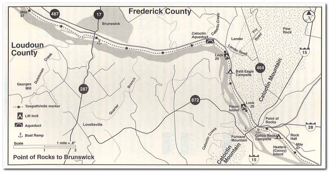
Day three on the canal started at shortly after ten in the morning. This time I walked the bridge back across the Potomac and began my hike along the towpath. At milepost 38.2 I passed by the site of the “Marble Quarry.” The quarry predated the C and O Canal and was said to run along the river for more than a mile. The stone that was quarried here was known as “Potomac marble” but it was quite different from the veined marble that was quarried in Tennessee and Georgia. Potomac marble was a limestone breccia composed of sharp angular pebbles cemented in a limestone matrix. After the British burned Washington in 1814 architect Benjumin Latrobe traveled up the Potomac to find marble for the two story columns in the House of Representatives chamber (now statuary Hall and the Senate chamber). The C and O Canal hadn’t been built yet, so the blocks of stone had to be boated down the river to Washington then transported to the site of the new capital building.
A short distance upriver from the quarry is Whites ford (milepost 39). This is the site where J.E.B. Stuart escaped back across the Potomac to Virginia in October 1862 after his ride around the Union army after the battle of Antietam.
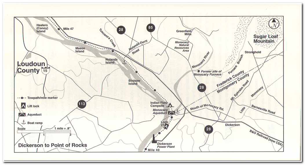
At milepost 41.5 is Lock #27. Confederate troops under General D.H. Hill, frustrated in their efforts to blow up the Monocacy Aqueduct at the outset of the Antietam campaign, turned their attention to disabling this lock on September 4th and 5th 1862. After the battle of Antietam, the canal company board dismissed the lockkeeper for allegedly collaborating with the Confederates. Several of his neighbors petitioned the board of directors on his behalf but to no avail.
At milepost 42.2 I crossed the Monocacy Aqueduct, a 560 foot long elevated portion of the Canal is divided into seven 54 foot arches and carries the canal over the Monocacy River. It was here that Hill tried to disable the canal. To expedite his crossing into Maryland Hill’s men leveled the canal banks, drained the canal and laid a corduroy path across the canal. While they were unable the destroy the aqueduct for lack of explosives they did wreck a portion of Lock #27. On Lee’s orders, a second attempt to demolish the aqueduct was made by General John Walker on the night of September 9th, but was unsuccessful. As Union troops approached, Walkers men had to move on, crossing back over the Potomac on their way to Loudoun Heights to complete the encirclement of Harpers Ferry.
Milepost 44.6, Noland’s Ferry. Here many of the 500 or so British and German prisoners from Saratoga (1778) crossed at the ferry on their way to prison camps in Virginia. It was a difficult winter crossing, with the scows frequently trapped by ice floes and drifting as far as a mile below the ferry crossing. This route became less used as the city of Washington was built further downstream. It was an occasional crossing point furing the Civil War for small outfits such as Mosby’s famous Partisan Rangers, who were based across the river in Loudoun County.
Pages: « Previous 1 2 3 4 5 6 7 8 9 10 11 12 13 14 15 16 17 18 19 20 21 Next »